Pennsylvania Route 865
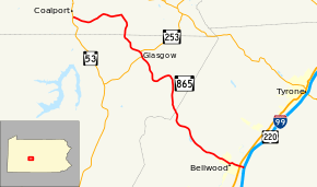
Pennsylvania Route 865 (PA 865) is a 19.1-mile-long (30.7 km) state highway located in Blair, Cambria, and Clearfield counties in Pennsylvania. The southern terminus is at I-99/US 220 in Bellwood. The northern terminus is at PA 53 in Coalport.
| ||||
|---|---|---|---|---|
 | ||||
| Route information | ||||
| Maintained by PennDOT | ||||
| Length | 19.088 mi[1] (30.719 km) | |||
| Major junctions | ||||
| South end | ||||
| ||||
| North end | ||||
| Location | ||||
| Counties | Blair, Cambria, Clearfield | |||
| Highway system | ||||
| ||||
Route description
PA 865 begins at an interchange with I-99/US 220 in Antis Township, Blair County, heading west on Old U.S. 220, a two-lane divided highway. The road runs through wooded areas and crosses Little Juniata River, coming to an intersection with US 220 Business. Past this intersection, the route becomes two-lane undivided Campbells Lane and passes homes and a few businesses, heading into Bellwood. Here, PA 865 becomes East Logan Street and heads west-northwest past residences, turning west and passing over Norfolk Southern's Pittsburgh Line. The route turns northwest onto North Tuckahoe Street and runs past more homes along with a few commercial establishments. The road heads back into Antis Township and continues through rural residential areas, passing through Roots Crossing. PA 865 passes a few forested fields before passing Bellwood Reservoir and heading into densely forested areas, turning to the north.[2][3]
PA 865 enters Reade Township in Cambria County and becomes Skyline Drive, continuing north through more forests and passing through Lloydville. The road turns to the southwest and runs through the residential community of Blandburg before heading through more wooded areas with some fields and homes, curving north again. The route passes through Mountaindale and heads northwest, coming to an intersection with PA 253 in Glasgow. At this point, PA 253 turns northwest to form a concurrency with PA 865, passing a few homes. PA 253 splits from PA 865 by turning east onto Executive Drive, with PA 865 winding northwest through woodland with a few agricultural clearings.[2][4] PA 865 continues into Beccaria Township in Clearfield County and becomes Heverly Boulevard, heading north through more woods with occasional farm fields. After passing through Utahville, the route turns to the west and heads through forested areas, passing through Heverly. Farther west, PA 865 reaches its northern terminus at an intersection with PA 53 on the southern border of Coalport.[2][5]
Major intersections
| County | Location | mi[1] | km | Destinations | Notes |
|---|---|---|---|---|---|
| Blair | Antis Township | 0.000– 0.175 | 0.000– 0.282 | Exit 41 (I-99) | |
| 0.316 | 0.509 | ||||
| Cambria | Reade Township | 12.057 | 19.404 | South end of PA 253 overlap | |
| 12.462 | 20.056 | North end of PA 253 overlap | |||
| Clearfield | Coalport | 19.088 | 30.719 | ||
1.000 mi = 1.609 km; 1.000 km = 0.621 mi
| |||||
See also


References
- Bureau of Maintenance and Operations (January 2019). Roadway Management System Straight Line Diagrams (Report) (2019 ed.). Pennsylvania Department of Transportation. Retrieved February 28, 2019.
- Blair County (PDF)
- Cambria County (PDF)
- Clearfield County (PDF)
- Google (July 18, 2011). "overview of Pennsylvania Route 865" (Map). Google Maps. Google. Retrieved July 18, 2011.
- Blair County, Pennsylvania Highway Map (PDF) (Map). PennDOT. 2018. Retrieved February 28, 2019.
- Cambria County, Pennsylvania Highway Map (PDF) (Map). PennDOT. 2018. Retrieved February 28, 2019.
- Clearfield County, Pennsylvania Highway Map (PDF) (Map). PennDOT. 2018. Retrieved February 28, 2019.
External links
![]()
