Pennsylvania Route 308
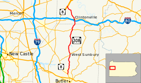
Pennsylvania Route 308 (PA 308) is a 28.5-mile-long (45.9 km) state highway located in Butler and Venango Counties in Pennsylvania. The southern terminus is at PA 8 near Butler. The northern terminus is at PA SR 3013 (Old PA 8) just north of the PA 8 junction in Pearl.
| ||||
|---|---|---|---|---|
 | ||||
| Route information | ||||
| Maintained by PennDOT | ||||
| Length | 28.5 mi[1] (45.9 km) | |||
| Major junctions | ||||
| South end | ||||
| North end | SR 3013 in Irwin Township | |||
| Location | ||||
| Counties | Butler, Venango | |||
| Highway system | ||||
| ||||
Route description
PA 308 begins at an intersection with PA 8 near the Clearview Mall in Center Township, Butler County, heading north on two-lane undivided West Sunbury Road. The road passes residential developments in the community of Windward Heights before heading into wooded areas with some farm fields and homes. The route passes over the Canadian National's Bessemer Subdivision railroad line and continues into agricultural areas with some woods and residences, crossing into Clay Township. PA 308 runs through more farmland and woodland with some homes, reaching an intersection with PA 138. At this point, PA 138 turns north to form a concurrency with PA 308 on Main Street, heading into the borough of West Sunbury. In this town, the road passes homes. Back into Clay Township, PA 138 splits from PA 308 by heading northeast onto North Washington Road. The route continues north on West Sunbury Road and runs through more woodland with some fields and homes. The road enters Cherry Township and continues through more rural areas, passing through Five Points, Moniteau, and Annandale. PA 308 crosses into Marion Township and heads through the residential community of Boyers before running through more wooded areas with a few fields and homes. The road comes to an intersection with PA 58 in Murrinsville and continues through farmland and woodland, curving northeast and heading into Venango Township.[1][2]
PA 308 enters Clinton Township in Venango County and becomes Butler Street, heading north through a mix of farms and woods with some homes and passing through Smith Corners. The route comes to an interchange with I-80 and heads into the borough of Clintonville, curving to the north-northwest and passing homes. In the center of town, the road crosses PA 208 and becomes Franklin Street, turning north through more residential areas. PA 308 heads into wooded areas with some homes and turns northwest, crossing back into Clinton Township. The route curves north and becomes an unnamed road, passing through more rural areas. The road heads into areas of woods and farm fields as it comes to Bullion and turns northwest. The route continues into Irwin Township and runs through more rural areas, coming to an interchange with the PA 8 freeway. A short distance later, PA 308 comes to its northern terminus at SR 3013 (Old Route 8).[1][3]
Major intersections
| County | Location[4] | mi[5] | km | Destinations | Notes |
|---|---|---|---|---|---|
| Butler | Center Township | 0.000 | 0.000 | Southern terminus | |
| Clay Township | 7.612 | 12.250 | Southern end of concurrency with PA 138 | ||
| 8.197 | 13.192 | Northern end of concurrency with PA 138 | |||
| Marion Township | 18.127 | 29.173 | |||
| Venango | Clinton Township | 21.744 | 34.994 | Exit 35 on I-80 | |
| Clintonville | 22.469 | 36.160 | |||
| Irwin Township | 28.223– 28.247 | 45.421– 45.459 | Interchange | ||
| 28.478 | 45.831 | SR 3013 (Old Route 8) | Northern terminus | ||
1.000 mi = 1.609 km; 1.000 km = 0.621 mi
| |||||
See also


References
- Google (August 28, 2011). "overview of Pennsylvania Route 308" (Map). Google Maps. Google. Retrieved August 28, 2011.
- Butler County, Pennsylvania Highway Map (PDF) (Map). PennDOT. 2011. Archived from the original (PDF) on August 7, 2011. Retrieved March 3, 2011.
- Venango County, Pennsylvania Highway Map (PDF) (Map). PennDOT. 2011. Archived from the original (PDF) on September 6, 2011. Retrieved May 23, 2011.
- "Video Log". Pennsylvania Department of Transportation. Retrieved September 17, 2016.
- Bureau of Maintenance and Operations (January 2016). Roadway Management System Straight Line Diagrams (Report) (2015 ed.). Pennsylvania Department of Transportation. Retrieved September 17, 2016.
