Pennsylvania Route 246
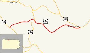
Pennsylvania Route 246 (PA 246) is an 8-mile-long (13 km) state highway located in McKean County in Pennsylvania. The western terminus is at PA 46 in Corwins Corners. The eastern terminus is at PA 346 in Prentisvale.
| ||||
|---|---|---|---|---|
 | ||||
| Route information | ||||
| Maintained by PennDOT | ||||
| Length | 8.456 mi[1] (13.609 km) | |||
| Existed | 1928–present | |||
| Major junctions | ||||
| West end | ||||
| East end | ||||
| Location | ||||
| Counties | McKean | |||
| Highway system | ||||
| ||||

Route description
PA 246 begins at an intersection with PA 46 in the community of Corwins Corners in Foster Township, heading east-northeast on two-lane undivided Looker Mountain Trail. The road passes wooded homes surrounded by forested mountains, running through the community of Dallas City. The route winds east through more forested areas as it comes into Otto Township and crosses PA 646 in the community of Summit. Past this intersection, PA 246 continues southeast through more mountainous areas. Upon reaching the residential community of Rixford, the route makes a turn to the northeast and heads into a mix of farmland and rural homes. PA 246 continues east through more rural areas to its eastern terminus at PA 346 in the community of Prentisvale.[2][3]
Major intersections
The entire route is in McKean County.
| Location | mi[1] | km | Destinations | Notes | |
|---|---|---|---|---|---|
| Foster Township | 0.000 | 0.000 | Western terminus of PA 246 | ||
| 2.911 | 4.685 | ||||
| Otto Township | 8.456 | 13.609 | Eastern terminus of PA 246 | ||
| 1.000 mi = 1.609 km; 1.000 km = 0.621 mi | |||||
See also


References
-
Bureau of Maintenance and Operations (January 2015). Roadway Management System Straight Line Diagrams (Report) (2015 ed.). Pennsylvania Department of Transportation. Archived from the original on February 17, 2011. Retrieved June 30, 2015.
- McKean County (PDF)
- Google (May 13, 2011). "overview of Pennsylvania Route 246" (Map). Google Maps. Google. Retrieved May 13, 2011.
- McKean County, Pennsylvania Highway Map (PDF) (Map). PennDOT. 2011. Retrieved May 13, 2011.