Peak to Peak Highway
The Peak to Peak Highway was established in 1918[1] and provides views of the Front Range Mountains in the Colorado Rocky Mountains. The route passes through the Colorado counties of Gilpin, Boulder, and Larimer.
| |
|---|---|
| Route information | |
| Length | 55 mi (89 km) |
| Existed | 1918–present |
| Major junctions | |
| South end | |
| North end | |
| Location | |
| Counties | Gilpin, Boulder, Larimer |
| Highway system | |
Colorado State Highways
| |

The route is classified as a scenic byway by the Colorado Department of Transportation (CDOT).[1] It was Colorado's first scenic roadway designation.
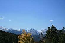
View on Peak to Peak Highway
40.188742°N 105.498694°W
.jpg)
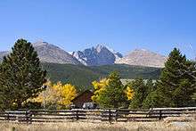
Aspen Trees on the Peak to Peak
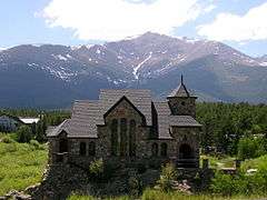
Chapel on the Rock (officially, Saint Catherine of Siena Chapel)
40.246940°N 105.535127°W
Parks & Recreation Areas
- Rocky Mountain National Park
- Golden Gate Canyon State Park
- Arapaho National Forest
- Roosevelt National Forest
- Indian Peaks Wilderness Area
- Eldorado Canyon State Park
Mountains and Peaks
- Apache Peak
- Copeland Mountain
- Long's Peak
- McHenrys Peak
- Meadow Mountain
- Mt Audubon
- Mt Jasper
- Ogalalla Peak
gollark: Even if tjwld stops the hate speech, we'll still have the idiocy...
gollark: Tjwlds be tjwlds.
gollark: Who says it's racist *or* idiot?
gollark: All hail turtlebots.
gollark: It would be slow and annoying.
References
- Colorado Department of Transportation. "Peak To Peak". Colorado Department of Transportation.
External links
This article is issued from Wikipedia. The text is licensed under Creative Commons - Attribution - Sharealike. Additional terms may apply for the media files.