Pattani, Thailand
Pattani is a town (thesaban mueang) in the far south of Thailand, near the border with Malaysia. It is the capital of Pattani Province. The city has a population of 44,353 (2018). It covers the whole tambon Sabarang, Anoru and Chabang Tiko of Mueang Pattani district.
Pattani ปัตตานี | |
|---|---|
| เทศบาลเมืองปัตตานี | |
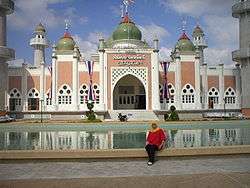 Central Mosque of Pattani | |
 Seal | |
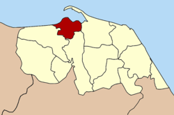 Location in Pattani Province | |
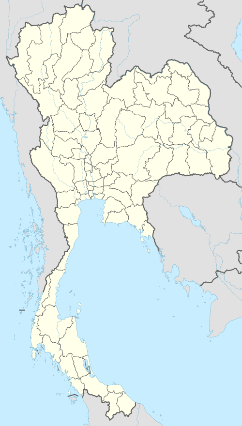 Pattani Location in Thailand | |
| Coordinates: 6°51′59″N 101°15′3″E | |
| Country | Thailand |
| Province | Pattani |
| District | Mueang Pattani |
| Government | |
| • Mayor | Pitak Korkiatpitak |
| Area | |
| • Town | 4.78 km2 (1.85 sq mi) |
| • Metro | 96.86 km2 (37.40 sq mi) |
| Population (2018) | |
| • Town | 44,353 |
| • Density | 9,300/km2 (24,000/sq mi) |
| Time zone | UTC+7 (ICT) |
| Area code | (+66) 73 |
| Website | pattanicity |
Some say the word Pattani is derived from "Petani" in Malay which means "farmer". Alternatively the name Pattani is the Thai adaptation of the Malay name Patani (Jawi: ڤتنا), which can mean "this beach" in Patani Malay language. (In standard Malay, this would be pantai ini.) Another suggestion is that it derives from a Sanskrit word pathini, meaning "virgin nymph"; Pathini was the name of a daughter of Merong Mahawangsa, founder of the preceding Langkasuka Empire. [1]
The local dialect of Malay is called Patani Malay or Yawi in Thai (derived from Jawi).
Pattani lies 1,056 km south of Bangkok.[2]
Climate
Pattani has a tropical monsoon climate according to the Köppen climate classification, with a lengthy wet season and a brief dry season. The temperatures and humidity are high year round, with slightly higher temperatures in April, just as the monsoon arrives. The wet season is long, lasting April-December, and the dry season short, covering only January-March. The months of October, November, and December are particularly wet.
| Climate data for Pattani (1981–2010) | |||||||||||||
|---|---|---|---|---|---|---|---|---|---|---|---|---|---|
| Month | Jan | Feb | Mar | Apr | May | Jun | Jul | Aug | Sep | Oct | Nov | Dec | Year |
| Record high °C (°F) | 34.3 (93.7) |
35.9 (96.6) |
37.0 (98.6) |
37.9 (100.2) |
38.0 (100.4) |
36.6 (97.9) |
36.3 (97.3) |
35.8 (96.4) |
36.0 (96.8) |
35.0 (95.0) |
34.0 (93.2) |
33.9 (93.0) |
38.0 (100.4) |
| Average high °C (°F) | 30.7 (87.3) |
32.0 (89.6) |
33.2 (91.8) |
34.1 (93.4) |
33.8 (92.8) |
33.3 (91.9) |
33.0 (91.4) |
32.9 (91.2) |
32.4 (90.3) |
31.6 (88.9) |
30.2 (86.4) |
29.6 (85.3) |
32.2 (90.0) |
| Daily mean °C (°F) | 26.0 (78.8) |
26.5 (79.7) |
27.3 (81.1) |
28.2 (82.8) |
28.2 (82.8) |
27.9 (82.2) |
27.6 (81.7) |
27.5 (81.5) |
27.2 (81.0) |
26.9 (80.4) |
26.3 (79.3) |
25.9 (78.6) |
27.1 (80.8) |
| Average low °C (°F) | 22.3 (72.1) |
22.1 (71.8) |
22.7 (72.9) |
23.6 (74.5) |
24.2 (75.6) |
24.0 (75.2) |
23.7 (74.7) |
23.7 (74.7) |
23.6 (74.5) |
23.6 (74.5) |
23.5 (74.3) |
23.0 (73.4) |
23.3 (73.9) |
| Record low °C (°F) | 18.6 (65.5) |
16.7 (62.1) |
18.5 (65.3) |
17.4 (63.3) |
21.6 (70.9) |
20.6 (69.1) |
20.4 (68.7) |
21.0 (69.8) |
20.8 (69.4) |
21.3 (70.3) |
21.0 (69.8) |
19.7 (67.5) |
16.7 (62.1) |
| Average rainfall mm (inches) | 50.9 (2.00) |
32.0 (1.26) |
49.4 (1.94) |
74.6 (2.94) |
137.5 (5.41) |
109.4 (4.31) |
129.1 (5.08) |
134.0 (5.28) |
147.1 (5.79) |
216.2 (8.51) |
406.6 (16.01) |
378.3 (14.89) |
1,865.1 (73.43) |
| Average rainy days | 7.5 | 3.1 | 5.7 | 7.3 | 13.2 | 11.0 | 12.8 | 13.2 | 15.5 | 18.3 | 20.4 | 17.3 | 145.3 |
| Average relative humidity (%) | 81 | 79 | 79 | 78 | 80 | 80 | 80 | 80 | 81 | 84 | 86 | 85 | 81 |
| Mean monthly sunshine hours | 145.7 | 166.7 | 148.8 | 144.0 | 114.7 | 111.0 | 114.7 | 114.7 | 108.0 | 111.6 | 105.0 | 108.5 | 1,493.4 |
| Mean daily sunshine hours | 4.7 | 5.9 | 4.8 | 4.8 | 3.7 | 3.7 | 3.7 | 3.7 | 3.6 | 3.6 | 3.5 | 3.5 | 4.1 |
| Source 1: Thai Meteorological Department[3] | |||||||||||||
| Source 2: Office of Water Management and Hydrology, Royal Irrigation Department (sun and humidity)[4] | |||||||||||||
References
- "{ms} Sejarah Malaysia - Asal Usul nama Sungai Petani". Sejarahmalaysia.pnm.my. Archived from the original on 2013-06-03. Retrieved 2012-08-24.
- "Distance: Bangkok to Pattani". Google Maps. Retrieved 22 May 2015.
- "Climatological Data for the Period 1981–2010". Thai Meteorological Department. p. 26. Retrieved 8 August 2016.
- "ปริมาณการใช้น้ำของพืชอ้างอิงโดยวิธีของ Penman Monteith (Reference Crop Evapotranspiration by Penman Monteith)" (PDF) (in Thai). Office of Water Management and Hydrology, Royal Irrigation Department. p. 126. Retrieved 8 August 2016.