Paterson Plank Road
Paterson Plank Road is a road that runs through Passaic, Bergen and Hudson Counties in northeastern New Jersey. The route, originally lain in the colonial era, connects the city of Paterson and the Hudson River waterfront. It has largely been superseded by Route 3, but in the many towns it passes it has remained an important local thoroughfare, and in some cases been renamed.
| |
|---|---|
| Route information | |
| Component highways | |
| Passaic / Bergen Counties segment | |
| West end | Temple Street / Presidential Boulevard in Paterson |
| East end | Dead end in Carlstadt |
| Hudson County segment | |
| West end | Dead end in Secaucus |
| East end | Observer Highway in Jersey City |
| Highway system | |
New Jersey State Highway Routes
| |


History
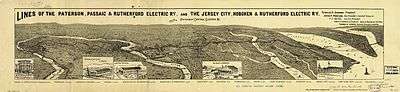
Portions of the road were at times called New Barbadoes Turnpike, from New Barbadoes Neck,[1] the name of the peninsula between the rivers it crossed, the Hackensack and the Passaic. Many plank roads in the United States were developed in the 19th century and consisted of laying boards side-to-side to prevent coach and wagon wheels from getting bogged down in soft or swampy ground, and to reduce travel times with a uniform surface. Normally a toll was charged. This technology was applied to the Paterson Plank Road and similar roads, the Hackensack Plank Road and the Newark Plank Road, which also traversed the Hackensack Meadows to the cities for which they are named. The Bergen Point Plank Road travelled from Paulus Hook to the Kill Van Kull. The company which built the Paterson and New York Plank Road, as it was called, received its charter on March 14, 1851.[2] Over time it was upgraded and at one point had streetcar lines on its entire length operated by the Public Service Railway as the 15 Passaic, 17 Hudson, and 35 Secaucus.[3]
Passaic County
![]()
Bergen County
![]()
![]()
Several new hotels, restaurants and nightclubs were built in anticipation of the increase in traffic from Xanadu. The road passes to the north of the Meadowlands Sports Complex. The main road, Route 120, curves to the south to follow the eastern edge of the Sports Complex southward to NJ 3, but Paterson Plank Road continues eastward via an exit ramp. Shortly after crossing over the Western Spur of the New Jersey Turnpike it reaches the Hackensack River. The original bridge over the Hackensack River was destroyed by 1940.[5] There was a proposal to rebuild the bridge as part of an extension to the Hudson–Bergen Light Rail,[6] but this was superseded by the new Meadowlands Rail Line, which traverses the Hackensack River via the Berrys Creek railroad bridge.[7]
Major intersections
The entire route is in Bergen County.
| Location | mi[8] | km | Destinations | Notes | |
|---|---|---|---|---|---|
| Passaic River | 0.0 | 0.0 | Bridge (continuation into Passaic County) | ||
| Wallington | 0.1 | 0.16 | Carlton Avenue (CR S69) | ||
| East Rutherford | 1.4 | 2.3 | Hoboken Road (CR S55) | ||
| 2.4 | 3.9 | Interchange; northern terminus of Route 120; southern terminus of CR 120 | |||
| 3.9 | 6.3 | Interchange; Route 120 transitions to/from Paterson Plank Road | |||
| 5.0 | 8.0 | Outwater Lane | |||
1.000 mi = 1.609 km; 1.000 km = 0.621 mi
| |||||
Hudson County
![]()
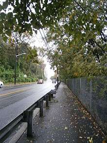
At the edge of the cliff turning south-southwest it is joined by the Wing Viaduct and descends the eastern side of the Palisades into Hoboken where it ends at Observer Highway.[11] In 2009, a study was funded for exploring the re-routing of the road near its terminus.[12] The last portion is one of the few roads that run along the face of the Hudson Palisades escarpment other being the Hackensack Plank Road, the Wing Viaduct, Pershing Road, and Bulls Ferry Road. Two streets join this part: Holland Street and Mountain Road,[13] the latter making a smaller and larger hairpin turn between Jersey City Heights and Hoboken. (Shippen Street in Weehawken makes a double hairpin.) New Jersey Transit bus routes 82 and 85 make use of the road.
Major intersections
The entire route is in Hudson County.
| Location | mi[14] | km | Destinations | Notes | |
|---|---|---|---|---|---|
| Secaucus | 0.0 | 0.0 | Dead end | ||
| 0.6 | 0.97 | Interchange | |||
| 1.3 | 2.1 | Westbound exit only; exit 16E on NJ Turnpike | |||
| 1.7 | 2.7 | ||||
| North Bergen | 2.2 | 3.5 | Interchange | ||
| 2.3 | 3.7 | Interchange; northbound entrance only | |||
| Union City | 3.7 | 6.0 | |||
| 3.8 | 6.1 | ||||
| Jersey City | 4.0 | 6.4 | |||
| Union City | 4.3 | 6.9 | |||
| 4.4 | 7.1 | ||||
| Jersey City | 5.4 | 8.7 | Continues east as Observer Highway | ||
| 1.000 mi = 1.609 km; 1.000 km = 0.621 mi | |||||
See also


- List of turnpikes in New Jersey
- Jersey City, Hoboken and Rutherford Electric Railway
- List of crossings of the Hackensack River
References
- Snyder, John P. (1969). The Story of New Jersey's Civil Boundaries: 1606-1968. Bureau of Geology and Topography.
- Laws of the State of New Jersey, 1811, pp. 337-340
- Modal, Eric (August 18, 2010). "The plank in the Paterson Plank Road". Journeys into New Jersey. New Jersey News Room. Archived from the original on August 27, 2014. Retrieved 2012-11-08.
- "Masonry and Metal The Historic Bridges of Bergen County, New Jersey" (PDF). Richard Grubb and Associates. 2008. Archived from the original (PDF) on 2012-07-10. Retrieved 2012-08-21.
- Weehawken - NJ / NY (Map). United States Geological Service.
- Stessel, Dan (October 24, 2005). "HUDSON-BERGEN LIGHT RAIL ARRIVING AT WEEHAWKEN'S PORT IMPERIAL STATION". NJ Transit.
- "N.J. officials launch rail service to Meadowlands". Associated Press. 2009-07-20. Retrieved 2009-10-09.
- Google (May 21, 2019). "Paterson Plank Road" (Map). Google Maps. Google. Retrieved May 21, 2019.
- "Hudson County 681 straight line diagram" (PDF). New Jersey Department of Transportation. Retrieved 2017-04-08.
- Trolley Park
- Hudson County New Jersey Street Map. Hagstrom Map Company, Inc. 2008. ISBN 0-88097-763-9.
- Baldwin, Carly (April 1, 2009). "Study may re-route Paterson Plank Road in Hoboken". NJ.com.
- "Hudson County 731 straight line diagram" (PDF). New Jersey Department of Transportation. Archived from the original (PDF) on 2012-10-17. Retrieved 2017-04-08.
- Google (May 21, 2019). "Paterson Plank Road" (Map). Google Maps. Google. Retrieved May 21, 2019.