Parish of Yalpunga
Yalpunga located at 29°02′40″S 142°03′13″E is a civil parish of Tongowoko County, New South Wales.[1][2]
Geography
Yalpunga is on the Queensland border and on the Yalpunga and wanpah creeks.[3] Yalpunga's is also on the Silver City Highway, 13.5 miles from Sturt National Park, and 46km from Tibooburra.[4] The parish has a Köppen climate classification of BWh (Hot desert)[5]. The County is barely inhabited with a population density of less than 1 person per 150km² and the landscape is a flat arid scrubland.
The Dingo Fence passes through the parish, which being in the Channel Country is flat arid scrubland.
History
A town was planned for Yalpunga in 1893,[6] but it never developed.
The path of totality for the Solar eclipse of November 25, 2030 and October 2042 will pass over the parish.
References
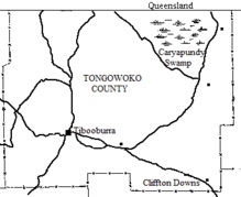
- Map of the County of Tongowoko.
- Yalpunga, maplandi.com
- Map of Yalpunga Creek, NSW, Bonzle.com
- Yalpunga, maplandisa.com.
- Peel, M. C.; Finlayson, B. L.; McMahon, T. A. (2007). "Updated world map of the Köppen–Geiger climate classification". Hydrol. Earth Syst. Sci. 11: 1633–1644. doi:10.5194/hess-11-1633-2007. ISSN 1027-5606. (direct: Final Revised Paper)
- New South Wales. Parliament. Legislative Council, Votes & Proceedings, Volume 2 (Parliament New South Wales, 1803 ) p39.31.