Parish of Tooncurrie
Tooncurrie Parish located at 29°31′44″S 142°13′52″E just east of Tibooburra, New South Wales is a cadastral parish of Tongowoko County New South Wales.[1] The town of Tibooburrais just outside the parish.[2]
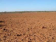
landscape near Tooncurrie
Geography
The Geography, of the parish is mostly the flat, arid landscape of the Channel Country. The parish has a Köppen climate classification of BWh (Hot desert)[3]. The County is barely inhabited with a population density of less than 1 person per 150km² and the landscape is a flat arid scrubland.
Gold was found in the area in the 1870 but today the parish is just inside the Sturt National Park. Water scarcity has always been a problem to habitation.
Other than Sturt National Park, the main feature of the parish is Tibooburra airport.
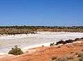 Landscape of Tongawoko County near Tooncurrie Parish
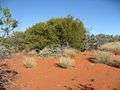 Landscape in the parish adjoining Tooncurry.
gollark: ?emojistats
gollark: ❌ ❌ ❌ ❌ ❌ ❌ ❌ ❌ ❌ ❌ ❌ ❌ ❌ ❌ ❌ ❌ ❌ ❌ ❌ ❌ ❌ ❌ ❌ ❌ ❌ ❌ ❌ ❌ ❌ ❌ ❌ ❌ ❌ ❌ ❌ ❌ ❌ ❌ ❌ ❌ ❌ ❌ ❌ ❌ ❌ ❌ ❌ ❌ ❌ ❌ ❌ ❌
gollark: ❌ ❌ ❌ ❌ ❌ ❌ ❌ ❌ ❌ ❌ ❌ ❌ ❌ ❌ ❌ ❌ ❌ ❌ ❌ ❌ ❌ ❌ ❌ ❌ ❌ ❌ ❌ ❌ ❌ ❌ ❌ ❌ ❌ ❌ ❌ ❌ ❌ ❌ ❌ ❌ ❌ ❌ ❌ ❌ ❌ ❌ ❌ ❌ ❌ ❌ ❌ ❌
gollark: Ah, at last.
gollark: ?emojistats
References
- "Tongowoko". Geographical Names Register (GNR) of NSW. Geographical Names Board of New South Wales. Retrieved 4 August 2013.

- Map of the County of Tongowoko: Western Division, Land District of Willyama.
- Peel, M. C.; Finlayson, B. L.; McMahon, T. A. (2007). "Updated world map of the Köppen–Geiger climate classification". Hydrol. Earth Syst. Sci. 11: 1633–1644. doi:10.5194/hess-11-1633-2007. ISSN 1027-5606. (direct: Final Revised Paper)
This article is issued from Wikipedia. The text is licensed under Creative Commons - Attribution - Sharealike. Additional terms may apply for the media files.