Paplitz (Baruth/Mark)
Paplitz (German: [ˈpaːpˌlɪts]) is a village, part of the town of Baruth/Mark and a former municipality in the Teltow-Fläming district, in Brandenburg, Germany. It is situated in the Glogau-Baruther Urstromtal at the border of the Fläming Heath, 3 km west of Baruth and 53 km south of Berlin.
Paplitz | |
|---|---|
Stadtteil of Baruth/Mark | |
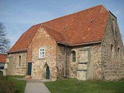 Church in Paplitz | |
Location of Paplitz (Baruth/Mark) %26groups%3D_1fccca5e025277e6c482fff016535137321cdda6.svg)
| |
 Paplitz  Paplitz | |
| Coordinates: 52°3′7″N 13°28′9″E | |
| Country | Germany |
| State | Brandenburg |
| District | Teltow-Fläming |
| Town | Baruth/Mark |
| Area | |
| • Total | 18.24 km2 (7.04 sq mi) |
| Elevation | 48 m (157 ft) |
| Population (2013-02-21) | |
| • Total | 359 |
| • Density | 20/km2 (51/sq mi) |
| Time zone | CET/CEST (UTC+1/+2) |
| Postal codes | 15837 |
| Dialling codes | 033704 |
| Vehicle registration | TF |
History
Paplitz, like most places in Brandenburg, was originally a Slavic settlement. It was first mentioned in a charter of the Bishopric of Brandenburg in 1363. Its name may derive from the Wendish term Popelicz meaning poplar grove.
Since 31 December 2001, Paplitz is part of the town of Baruth.[1]
gollark: Your specific example isn't very deathy, I mean.
gollark: That doesn't seem very deathy.
gollark: Or, well, everyone is very sure but in different ways.
gollark: It's a hard philosophy problem. Nobody is very sure.
gollark: You believe in *two* dimensions? Government shill.
External links
![]()
- Official website (in German)
- Paplitz at the Official website of Baruth/Mark (in German)
References
This article is issued from Wikipedia. The text is licensed under Creative Commons - Attribution - Sharealike. Additional terms may apply for the media files.