Papago Army Heliport
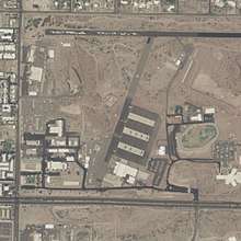
Papago Army Heliport (FAA LID: P18) is a United States Army heliport at Papago Park Military Reservation. It is home to the 2nd Battalion, 285th Aviation Regiment. The airport is 6 miles (5.2 nmi; 9.7 km) east of the central business district of Phoenix, a city in Maricopa County, Arizona, United States. It is 3.5 miles (3.0 nmi; 5.6 km) northeast of Phoenix Sky Harbor International Airport.[1]
Papago Army Heliport | |||||||||||
|---|---|---|---|---|---|---|---|---|---|---|---|
 | |||||||||||
| Summary | |||||||||||
| Airport type | Military | ||||||||||
| Owner/Operator | United States Army | ||||||||||
| Location | Phoenix, Arizona | ||||||||||
| Elevation AMSL | 1,250 ft / 381 m | ||||||||||
| Coordinates | 33°28′19″N 111°57′50″W | ||||||||||
| Map | |||||||||||
 P18  P18 | |||||||||||
| Helipads | |||||||||||
| |||||||||||
Although most U.S. airports use the same three-letter location identifier for the FAA, IATA, and ICAO, this airport is only assigned P18 by the FAA.[2]
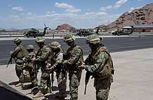
Soldiers at Papago Army Heliport
Facilities and aircraft
Papago Army Heliport is at an elevation of 1,250 ft (380 m) above mean sea level. It has one asphalt helipad:
- 12/30 measuring 600 ft × 400 ft (180 m × 120 m)[3]
gollark: Platinum would go down in value and we could all have nice platinum things.
gollark: I don't want people to be able to claim random asteroids without visiting them.
gollark: Mostly because it doesn't seem very economically viable, because there is no spacey infrastructure.
gollark: But they don't.
gollark: If someone had valuable assets up there the legal issues would be worked out.
References
- "AirportIQ 5010". www.gcr1.com. Retrieved 2018-06-16.
- "P18 - Phoenix [Papago Army Heliport], AZ, US - Heliport - Great Circle Mapper". www.gcmap.com. Retrieved 2018-06-16.
- "AOPA Airports". www.aopa.org. Retrieved 2018-06-16.
External links
- Arizona Army National Guard at Papago Park
- 285th Attack Reconnaissance Battalion
- Resources for this airport:
- FAA airport information for P18
- AirNav airport information for KP18
- FlightAware airport information and live flight tracker
- NOAA/NWS weather observations: current, past three days
- SkyVector aeronautical chart, Terminal Procedures
This article is issued from Wikipedia. The text is licensed under Creative Commons - Attribution - Sharealike. Additional terms may apply for the media files.