Palos Blancos, Corozal, Puerto Rico
Palos Blancos is a barrio in the municipality of Corozal, Puerto Rico. Its population in 2010 was 3,458.[3][4][5]
Palos Blancos | |
|---|---|
Barrio | |
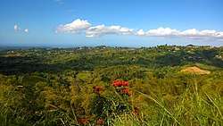 View from Palos Blancos | |
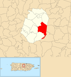 Location of Palos Blancos within the municipality of Corozal shown in red | |
 Palos Blancos Location of Puerto Rico | |
| Coordinates: 18°17′27″N 66°18′09″W[1] | |
| Commonwealth | |
| Municipality | |
| Area | |
| • Total | 4.98 sq mi (12.9 km2) |
| • Land | 4.98 sq mi (12.9 km2) |
| • Water | 0 sq mi (0 km2) |
| Elevation | 1,345 ft (410 m) |
| Population (2010) | |
| • Total | 3,458 |
| • Density | 695.8/sq mi (268.6/km2) |
| Source: 2010 Census | |
| Time zone | UTC−4 (AST) |
History
The United States took control of Puerto Rico from Spain in the aftermath of the Spanish-American War under the terms of the Treaty of Paris of 1898. In 1899, the United States conducted its first census of Puerto Rico finding that the population of Palos Blancos barrio was 1,367.[6]
Monte Choca State Forest
Located in Palos Blancos barrio is Monte Choca State Forest which was declared a state forest with law # 295 on November 21, 2003.[7][8][9][10] Its area is about 244.76 acres and it is located at one of the highest elevations in Corozal.[11]
Sectors
Barrios (which are like minor civil divisions)[12] in turn are further subdivided into smaller local populated place areas/units called sectores (sectors in English). The types of sectores may vary, from normally sector to urbanización to reparto to barriada to residencial, among others.[13][14][15]
The following sectors are in Palos Blancos barrio:[16]
Parcelas Medina, Sector Amado Suárez, Sector Baldino Ortiz, Sector Carretera (from Ángel Vázquez to Manuel Ortiz), Sector Colón, Sector Demetrio Pacheco, Sector El Cacique, Sector El Pegao, Sector El Siete (7), Sector Gobeo, Sector Héctor Ortiz, Sector La Arena, Sector La Loma, Sector La Perla, Sector La Pollera, Sector La Quinta, Sector La Riviera, Sector La Vega, Sector Lino Caldero, Sector Los Morales, Sector Los Rodríguez, Sector Los Bagué, Sector Los Febus, Sector Los Guzmanes, Sector Los Morales (Emérito), Sector Los Padilla, Sector Los Ramos, Sector Los Ruiz, Sector Los Velilla, Sector Maná, Sector Manuel Ortiz, Sector Marcelino López, Sector Nono Negrón, Sector Pepe Córdova, Sector Pepín Rodríguez, Sector Quiliche, Sector Rolo Pacheco, Sector Pura Molina, Sector Tato López, Sector Varela, and Sector Virella.
References
- "US Gazetteer 2019". US Census. US Government.
- U.S. Geological Survey Geographic Names Information System: Palos Blancos barrio
- Picó, Rafael; Buitrago de Santiago, Zayda; Berrios, Hector H. Nueva geografía de Puerto Rico: física, económica, y social, por Rafael Picó. Con la colaboración de Zayda Buitrago de Santiago y Héctor H. Berrios. San Juan Editorial Universitaria, Universidad de Puerto Rico,1969.
- Gwillim Law (20 May 2015). Administrative Subdivisions of Countries: A Comprehensive World Reference, 1900 through 1998. McFarland. p. 300. ISBN 978-1-4766-0447-3. Retrieved 25 December 2018.
- Puerto Rico:2010:population and housing unit counts.pdf (PDF). U.S. Dept. of Commerce, Economics and Statistics Administration, U.S. Census Bureau. 2010.
- Joseph Prentiss Sanger; Henry Gannett; Walter Francis Willcox (1900). Informe sobre el censo de Puerto Rico, 1899, United States. War Dept. Porto Rico Census Office (in Spanish). Imprenta del gobierno. p. 161.
- "Ley Núm. 295 de 21 de Noviembre de 2003. Ley que crea Bosque Monte Choca del Barrio Palos Blancos de Corozal". vLex (in Spanish).
- http://www.oslpr.org/download/es/2003/0295c3628.pdf
- http://www.drna.pr.gov/wp-content/uploads/2015/04/El-Bosque-Estatal-Monte-Choca.pdf
- Adrian Hailey; Byron Wilson; Julia Horrocks (7 April 2011). Conservation of Caribbean Island Herpetofaunas Volume 2: Regional Accounts of the West Indies. BRILL. pp. 342–. ISBN 978-90-04-19409-0.
- "Aventura dentro por el Bosque Monte Choca en Corozal". El Nuevo Dia (in Spanish). 7 June 2015.
- "US Census Barrio-Pueblo definition". factfinder.com. US Census. Archived from the original on 13 May 2017. Retrieved 5 January 2019.
- "Agencia: Oficina del Coordinador General para el Financiamiento Socioeconómico y la Autogestión (Proposed 2016 Budget)". Puerto Rico Budgets (in Spanish). Retrieved 28 June 2019.
- Rivera Quintero, Marcia (2014), El vuelo de la esperanza: Proyecto de las Comunidades Especiales Puerto Rico, 1997-2004 (first ed.), San Juan, Puerto Rico Fundación Sila M. Calderón, ISBN 978-0-9820806-1-0
- "Leyes del 2001". Lex Juris Puerto Rico (in Spanish). Retrieved 24 June 2020.
- "PRECINTO ELECTORAL COROZAL 072" (PDF). Comisión Estatal de Elecciones (in Spanish). PR Government. 21 September 2019. Retrieved 24 June 2020.