Paisley, Ontario
Paisley is an unincorporated community and village in the municipality of Arran–Elderslie, Bruce County in Southwestern Ontario, Canada.[1][3][4][5] Paisley is defined by its position at the confluence of the Saugeen River and the Teeswater River, and at the junction of Bruce Roads 1, 11, and 3.
Paisley | |
|---|---|
Community | |
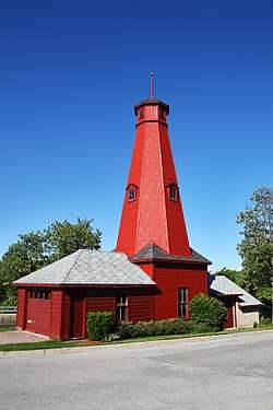
 Historic Hose Tower in Paisley, built in 1891 | |
| Etymology: Named after Paisley, Renfrewshire | |
 Paisley Location in southern Ontario | |
| Coordinates: 44°18′27″N 81°16′27″W[1] | |
| Country | Canada |
| Province | Ontario |
| County | Bruce County |
| Municipality | Arran–Elderslie |
| First settled | 1851 |
| Elevation | 217 m (712 ft) |
| Time zone | UTC-5 (Eastern Time Zone) |
| • Summer (DST) | UTC-4 (Eastern Time Zone) |
| Postal code | N0G 2N0 |
| Area code(s) | 519, 226, 548 |
| CGNDB key | FAXPT |
History
Paisley began with the settlement in 1851 of Simon Orchard and Samuel T. Rowe at the site of what would become the village of Paisley. The village was named in 1856 after Paisley, Renfrewshire in Scotland.[6]
Notable persons
- Alexander James McPhail, an agricultural reformer, was born in Paisley in 1883.
- Marshall Kay, a paleontologist prominently involved with the study of continental drift, was born in Paisley in 1904.
- Isabella Valancy Crawford, a prolific Canadian author, lived in Paisley between 1857 and 1861.
Climate
| Climate data for Paisley | |||||||||||||
|---|---|---|---|---|---|---|---|---|---|---|---|---|---|
| Month | Jan | Feb | Mar | Apr | May | Jun | Jul | Aug | Sep | Oct | Nov | Dec | Year |
| Record high °C (°F) | 12.2 (54.0) |
14.0 (57.2) |
23.0 (73.4) |
28.5 (83.3) |
32.2 (90.0) |
33.9 (93.0) |
34.5 (94.1) |
35.0 (95.0) |
32.8 (91.0) |
27.2 (81.0) |
21.0 (69.8) |
18.5 (65.3) |
35.0 (95.0) |
| Average high °C (°F) | −3.2 (26.2) |
−2.6 (27.3) |
2.5 (36.5) |
10.2 (50.4) |
17.8 (64.0) |
22.1 (71.8) |
25.0 (77.0) |
24.0 (75.2) |
19.5 (67.1) |
12.8 (55.0) |
5.9 (42.6) |
−0.5 (31.1) |
11.1 (52.0) |
| Daily mean °C (°F) | −7 (19) |
−6.9 (19.6) |
−2.2 (28.0) |
5.1 (41.2) |
11.5 (52.7) |
15.9 (60.6) |
18.9 (66.0) |
18.2 (64.8) |
14.1 (57.4) |
8.2 (46.8) |
2.5 (36.5) |
−3.8 (25.2) |
6.2 (43.2) |
| Average low °C (°F) | −10.7 (12.7) |
−11.3 (11.7) |
−6.8 (19.8) |
0.1 (32.2) |
5.2 (41.4) |
9.6 (49.3) |
12.7 (54.9) |
12.4 (54.3) |
8.8 (47.8) |
3.5 (38.3) |
−0.9 (30.4) |
−7.1 (19.2) |
1.3 (34.3) |
| Record low °C (°F) | −37.2 (−35.0) |
−40.0 (−40.0) |
−33.0 (−27.4) |
−18.9 (−2.0) |
−6.1 (21.0) |
−2.2 (28.0) |
2.2 (36.0) |
0 (32) |
−5.5 (22.1) |
−8.3 (17.1) |
−17.5 (0.5) |
−31 (−24) |
−40 (−40) |
| Average precipitation mm (inches) | 144 (5.7) |
93 (3.7) |
88.4 (3.48) |
70.3 (2.77) |
75.5 (2.97) |
76.4 (3.01) |
73.9 (2.91) |
101.2 (3.98) |
111 (4.4) |
98.2 (3.87) |
110.7 (4.36) |
150 (5.9) |
1,192.7 (46.96) |
| Average rainfall mm (inches) | 18.4 (0.72) |
23.4 (0.92) |
50.7 (2.00) |
60.1 (2.37) |
75.4 (2.97) |
76.4 (3.01) |
73.9 (2.91) |
101.2 (3.98) |
111 (4.4) |
97.2 (3.83) |
74.3 (2.93) |
40.6 (1.60) |
802.6 (31.60) |
| Average snowfall cm (inches) | 125.7 (49.5) |
69.6 (27.4) |
37.7 (14.8) |
10.3 (4.1) |
0.1 (0.0) |
0 (0) |
0 (0) |
0 (0) |
0 (0) |
1 (0.4) |
36.4 (14.3) |
109.4 (43.1) |
390.1 (153.6) |
| Source: Environment Canada[7] | |||||||||||||
gollark: Didn't for me.
gollark: Self-contained VFS bundles?
gollark: PotatOS may gain native support for loading them though.
gollark: I do it by making the bundles self-executing and self-contained.
gollark: They are compressed though.
References
- "Paisley". Geographical Names Data Base. Natural Resources Canada. Retrieved 2012-07-26.
- Elevation taken from Google Maps at coordinates. Accessed 2018-07-03.
- "CLAIMaps IV". Ontario Ministry of Northern Development and Mines. 2016. Retrieved 2018-07-03.
- Map 4 (PDF) (Map). 1 : 700,000. Official road map of Ontario. Ministry of Transportation of Ontario. 2016-01-01. Retrieved 2018-07-03.
- Restructured municipalities - Ontario map #6 (Map). Restructuring Maps of Ontario. Ontario Ministry of Municipal Affairs and Housing. 2006. Retrieved 2018-07-03.
- Rayburn, Alan (1997). Place names of Ontario. Toronto: University of Toronto Press. p. 263. ISBN 0-8020-7207-0. Retrieved 21 October 2017.
- Environment Canada—, accessed 7 May 2013
- Robertson, Norman (1906). "The History of the County of Bruce and of the minor municipalities therein, Province of Ontario, Canada". William Briggs (via ouroots.ca). Retrieved 2008-10-09.
External links
- Paisley and District Chamber of Commerce
- Municipality of Arran-Elderslie
- Bruce County Official Website
This article is issued from Wikipedia. The text is licensed under Creative Commons - Attribution - Sharealike. Additional terms may apply for the media files.