Pa Daet District
Pa Daet (Thai: ป่าแดด; IPA: [pàː dɛ̀ːt]) is a district (amphoe) in the southern part of Chiang Rai Province, northern Thailand.
Pa Daet ป่าแดด | |
|---|---|
.png) Samakkhi Rat Rangsarn School in Pa Ngae, Pa Daet | |
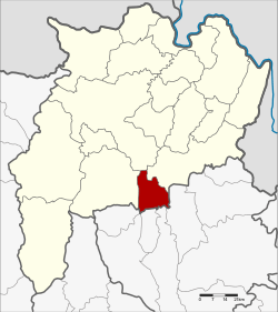 District location in Chiang Rai Province | |
| Coordinates: 19°30′15″N 99°59′35″E | |
| Country | Thailand |
| Province | Chiang Rai |
| Seat | Pa Daet |
| Area | |
| • Total | 333.3 km2 (128.7 sq mi) |
| Population (2005) | |
| • Total | 26,628 |
| • Density | 79.9/km2 (207/sq mi) |
| Time zone | UTC+7 (ICT) |
| Postal code | 57190 |
| Geocode | 5706 |
History
The area of Pa Daet was originally dense forest of the Phan District. People from other places went there to hunt animals and settle new villages. It was created as the minor district (king amphoe) Pa Daet on 1 June 1969, consisting of the single tambon, Pa Daet.[1] The minor district was upgraded to a full district on 21 August 1975.[2]
Geography
Neighboring districts are (from the west clockwise): Phan, Mueang Chiang Rai, and Thoeng of Chiang Rai Province; Chun, Dok Khamtai, Phu Kamyao, Mueang Phayao, and Mae Chai of Phayao Province.
The Phi Pan Nam Mountains dominate the landscape of the district. The important water resource is the Ing River.
Administration
The district is divided into five sub-districts (tambons), which are further subdivided into 58 villages (mubans). There are two townships (thesaban tambons). Pa Daet covers parts of tambon Pa Daet, and Pa Ngae the whole tambon Pa Ngae. There are a further five tambon administrative organizations (TAO).
| No. | Name | Thai name | Villages | Pop. | |
|---|---|---|---|---|---|
| 1. | Pa Daet | ป่าแดด | 12 | 6,504 | |
| 2. | Pa Ngae | ป่าแงะ | 18 | 8,129 | |
| 3. | San Makha | สันมะค่า | 8 | 5,089 | |
| 5. | Rong Chang | โรงช้าง | 12 | 4,892 | |
| 6. | Si Pho Ngoen | ศรีโพธิ์เงิน | 8 | 2,014 |
Geocode 4 is not used.
References
- ประกาศกระทรวงมหาดไทย เรื่อง แบ่งท้องที่ตั้งเป็นกิ่งอำเภอ (PDF). Royal Gazette (in Thai). 86 (49 ง): 1863. 3 June 1969.
- พระราชกฤษฎีกาตั้งอำเภอแวงน้อย อำเภอป่าแดด อำเภอเรณูนคร อำเภอคูเมือง อำเภอคุระบุรี อำเภอแม่ลาน้อย อำเภอเสริมงาม อำเภอไพรบึง และอำเภอหนองโดน พ.ศ. ๒๕๑๘ (PDF). Royal Gazette (in Thai). 92 (166 ก special issue): 1–4. 21 August 1975.
External links

- amphoe.com
Chiang Rai | ||
|---|---|---|
| Main article |  | |
| Capital city | ||
| Districts (amphoe) |
| |
| Related topics |
| |