Oste
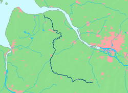
Oste (German pronunciation: [ˈʔoːstə], also [ˈɔstə]) is a river in northern Lower Saxony, Germany with a length of 149 km (93 mi). It is a left tributary of the Elbe.
| Oste | |
|---|---|
 | |
| Location | |
| Country | Germany |
| State | Lower Saxony |
| Physical characteristics | |
| Source | |
| • elevation | 31 m (102 ft) |
| Mouth | |
• location | Elbe |
• coordinates | 53°50′22″N 9°1′6″E |
| Length | 149.4 km (92.8 mi)[1] |
| Basin size | 1,715 km2 (662 sq mi)[1] |
| Basin features | |
| Progression | Elbe→ North Sea |
The Oste flows through the districts of Harburg, Rotenburg, Stade and Cuxhaven and empties into the Elbe river near Otterndorf. Its drainage area is 1.715 km2 (0.662 sq mi) and the decline between the source and the estuary is 31 m (102 ft). Tributaries are Ramme, Aue, Twiste, Bade, Bever and Mehe.
The Oste is part of the "Deutsche Fährstraße" established in May 2004, an institution similar to the American National Scenic Byways. It connects various places between Bremervörde and Kiel with relation to the history of ferries and crossing of rivers, like the historic transporter bridges in Rendsburg and Osten. Also at the Oste there are two pram ferries in Gräpel and Brobergen. The ferry in Gräpel is actually manually operated.
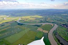
Although recognized as an official waterway the Oste has not much ship traffic.
The river has its source near Tostedt at the border of the Lüneburg Heath, flowing to the west passing Sittensen and Zeven, changing direction to north and passing Bremervörde, where influence of the tides is starting, Hemmoor and Neuhaus.
See also
References
- August Heinrich von Brook (Hrsg.): Die Oste. Lebensader zwischen Elbe und Weser. Aufsatzsammlung. Heimatbund der Männer vom Morgenstern, Bremerhaven 2003. ISBN 3-931771-39-3
- Willi Klenck: Heimatkunde des ehemaligen Kreises Neuhaus. Pockwitz, Stade 1957, Otterndorf 1986 (Faks.).
- Gisela Tiedemann, Jochen Bölsche: Über die Oste - Geschichten aus 100 Jahren Schwebefähre Osten - Hemmoor. Drochtersen 2009, ISBN 978-3-938097-17-5
External links
| Wikimedia Commons has media related to Oste. |
- Osteticker (in German)
- Deutsche Fährstraße (in German)
- Erlebnis Schwebefähre (in German)