Oregon Route 501
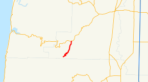
Oregon Route 501 (OR 501) is an Oregon state highway running from the town of Alsea south 9.49 miles where it abruptly ends and turns into Lobster Valley Road at the intersection of Hazel Glen Road near the Benton-Lane County line. OR 501 is known as the Alsea-Deadwood Highway No. 201 (see Oregon highways and routes). It is 9.49 miles (15.27 km) long[1] and runs north–south, entirely within Benton County.
| ||||
|---|---|---|---|---|
 | ||||
| Route information | ||||
| Maintained by ODOT | ||||
| Length | 9.49 mi[1] (15.27 km) | |||
| Existed | 2002–present | |||
| Major junctions | ||||
| South end | Lobster Valley Road near Alsea | |||
| North end | ||||
| Highway system | ||||
| ||||

OR 501 was established in 2002 as part of Oregon's project to assign route numbers to highways that previously were not assigned. In 2009, ODOT posted route shield signs at both termini and another intersection.
Route description
OR 501 begins at the intersection of OR 34 in the small rural town of Alsea, from there, it heads south through mostly forested, rural land, following the route of the original logging roads making it extremely curvy at its southern end where it abruptly ends and turns into county maintained Lobster Valley Road. [2]
History
The Alsea-Deadwood Highway was originally planned to start in the small logging town of Alsea, travel south through Lobster Valley, continuing to the small community of Paris and south to end at OR 36 in Deadwood. The Highway was never completed south to Paris from Lobster Valley and it was later decided by the Oregon Highway Commission to abandoned any future plans to complete the Highway as originally planned. ODOT designated the Alsea-Deadwood Highway as OR 501 in 2002.
OR 501 had been built with the intention to continue south to connect OR 34 from Alsea to OR 36 in Deadwood, hence the name "Alsea-Deadwood Highway". However, only 16 miles were completed on the north end from OR 34 to Preacher Creek Road with approximately 11 miles on the south end from OR 36 leaving an area in the middle unfinished. (Approximately 6 of the original 16 miles of the north side were turned over to Benton County, while the approximate 11 mile section running North from OR 36 was turned over to Lane County, leaving the current 9.49 miles from the small community of Alsea as the only section of OR 501 still maintained by ODOT)
ODOT has attempted to turn the Highway over to Benton County for several years, however the Highway is in such poor condition with several locations on active slide areas, Benton County has not been interested in taking over control of the Highway. The potential cost of fixing a major slide on the Highway could cost several million dollars due to the fact half the Highway is built on steep unstable ground. Because of the low traffic volume on the Highway, ODOT has never attempted to straighten, widen or upgrade it, they have also never completely resurfaced it causing it to fall somewhat in disrepair over the years.
OR 501 intersects with OR 34 in the small town of Alsea where it travels south and then approximately one mile south of Alsea, OR 501 intersects with South Fork Road. In 2019, ODOT designated this section of OR 501 as part of the Scenic Byway that goes to Alsea Falls.
Major intersections
The entire route is in Benton County.
| Location | mi[1] | km | Destinations | Notes | |
|---|---|---|---|---|---|
| | 9.49 | 15.27 | Lobster Valley Road | Southern terminus; road continues as Lobster Valley Road | |
| Alsea | 0.00 | 0.00 | Northern terminus | ||
| 1.000 mi = 1.609 km; 1.000 km = 0.621 mi | |||||
References
- Staff (November 2011). "ALSEA-DEADWOOD HIGHWAY No. 201" (PDF). Oregon Department of Transportation. Retrieved May 11, 2015.
- Google (May 11, 2015). "Oregon Route 501" (Map). Google Maps. Google. Retrieved May 11, 2015.