Oregon Route 237
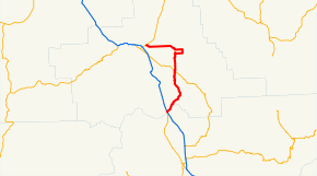
Oregon Route 237 is an Oregon state highway running from OR 82 in Island City to Interstate 84 and U.S. Route 30 in North Powder. OR 237 is composed of the Cove Highway No. 342 (see Oregon highways and routes) and part of the La Grande-Baker Highway No. 66. It is a combined 38.93 miles (62.65 km) long and runs generally northwest to southeast in an inverted L pattern.
| ||||
|---|---|---|---|---|
 | ||||
| Route information | ||||
| Maintained by ODOT | ||||
| Length | 38.93 mi (62.65 km) | |||
| Major junctions | ||||
| South end | ||||
| North end | ||||
| Highway system | ||||
| ||||

.jpg)
Snow removal on Route 237
Route description
OR 237 begins at an intersection with OR 82 in Island City. It heads east to Cove, where it turns south, then west, then south again to Union, where it overlaps OR 203 for 0.58 miles (0.93 km). After the concurrency ends, OR 237 continues south to an intersection with I-84 and US 30 in North Powder, where it ends.
Major intersections
The entire route is in Union County.
| Location | mi | km | Destinations | Notes | |
|---|---|---|---|---|---|
| Island City | 0.00 | 0.00 | |||
| Union | 22.07 | 35.52 | Begin concurrency | ||
| 22.65 | 36.45 | End concurrency | |||
| North Powder | 38.43 | 61.85 | |||
1.000 mi = 1.609 km; 1.000 km = 0.621 mi
| |||||
gollark: I agree.
gollark: Children are mostly not capable of self-supportingness.
gollark: I had to do ENGLISH LITERATURE for TWO YEARS!
gollark: I'm against most implementations.
gollark: I am not against education generally.
References
- Oregon Department of Transportation, Descriptions of US and Oregon Routes, https://web.archive.org/web/20051102084300/http://www.oregon.gov/ODOT/HWY/TRAFFIC/TEOS_Publications/PDF/Descriptions_of_US_and_Oregon_Routes.pdf, page 18.
- Oregon Department of Transportation, Cove Highway No. 342, ftp://ftp.odot.state.or.us/tdb/trandata/maps/slchart_pdfs_1980_to_2002/Hwy342_1996.pdf
- Oregon Department of Transportation, La Grande-Baker Highway No. 66, ftp://ftp.odot.state.or.us/tdb/trandata/maps/slchart_pdfs_1980_to_2002/Hwy066_2002.pdf
This article is issued from Wikipedia. The text is licensed under Creative Commons - Attribution - Sharealike. Additional terms may apply for the media files.