Oregon Route 104
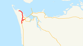
Oregon Route 104 (OR 104) is an Oregon state highway which connects US 101 near Warrenton with Fort Stevens State Park. OR 104 is known as the Fort Stevens Highway No. 104[2] (see Oregon highways and routes). It is 6.03 miles (9.70 km) long and runs north–south, entirely within Clatsop County.
| ||||
|---|---|---|---|---|
 | ||||
| Route information | ||||
| Maintained by ODOT | ||||
| Length | 6.03 mi[1] (9.70 km) | |||
| Existed | 2002–present | |||
| Major junctions | ||||
| South end | ||||
| North end | Fort Stevens State Park in Warrenton | |||
| Highway system | ||||
| ||||

The OR 104 designation was applied to the Fort Stevens Highway in 2002 as part of Oregon's project to assign route numbers to highways that did not have route numbers.[3]
Route description
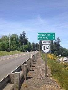
The southern terminus of OR 104 is at a junction with US 101 near south of Warrenton. It heads due north for 6 miles (9.7 km), ending at the entrance to Fort Stevens State Park near Hammond. The southern portion of the route constitutes an old portion of US 101. The spur, known as the Fort Stevens Spur No. 485, also constitutes an old portion of US 101.[4]
History
The Fort Stevens Highway No. 104 was established as a secondary highway in December 30, 1946.[4] On February 19, 1981, OR 104 was extended southward to an old alignment of US 101, while US 101 was moved to a new alignment.[4] On September 19, 2002, OR 104 was assigned to the Fort Stevens Highway.[3]
Major intersections
The entire route is in Clatsop County.
| Location | mi[1] | km | Destinations | Notes | |
|---|---|---|---|---|---|
| | 6.03 | 9.70 | |||
| Warrenton | 4.43 | 7.13 | |||
| 3.32 | 5.34 | East Harbor Street (Warrenton-Astoria Highway) | |||
| 0.00 | 0.00 | Fort Stevens State Park | |||
| 1.000 mi = 1.609 km; 1.000 km = 0.621 mi | |||||
Spur route
| |
|---|---|
| Location | Warrenton, Oregon |
| Length | 0.95 mi[5] (1.53 km) |
| Existed | 2002–present |
Oregon Route 104S is a spur route of Oregon Route 104, and connects OR 104 to U.S. Route 101 in Warrenton. OR 104S in known as the Fort Stevens Spur No. 485.[2]
References
- "Fort Stevens Highway No. 104 Straightline Chart" (PDF). Oregon Department of Transportation. Retrieved January 26, 2014.
- "Routes / State Highway Cross Reference Table". Oregon Department of Transportation. Retrieved January 26, 2014.
- "Descriptions of US and Oregon Routes" (PDF). Oregon Department of Transportation. July 2008. p. 14. Retrieved January 31, 2014.
- "History of State Highways in Oregon" (PDF). Oregon Department of Transportation. 2011. pp. 523–524. Retrieved February 6, 2014.
- "Fort Stevens Spur No. 485 Straightline Chart" (PDF). Oregon Department of Transportation. Retrieved January 31, 2014.