Oranga
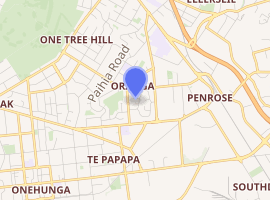
Oranga is a small residential suburb in Auckland, New Zealand. It is located nine kilometres to the southeast of the city centre, between the commercial suburbs of Te Papapa and Penrose to the south and east, and the residential suburbs of One Tree Hill and Onehunga to the north and south.
Oranga | |
|---|---|
Suburb | |

| |
| Country | New Zealand |
| Local authority | Auckland Council |
| Electoral ward | Maungakiekie-Tāmaki Ward |
| Local board | Maungakiekie-Tāmaki Local Board |
| Board subdivision | Maungakiekie |
| Population (2018) | |
| • Total | 3,198 |
| One Tree Hill | Greenlane | Ellerslie |
| Royal Oak |
|
Penrose |
| Onehunga | Onehunga | Te Papapa |
The New Zealand Ministry for Culture and Heritage gives a translation of "place of rising ground" for Ōranga.[1]
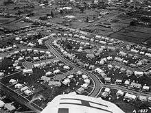
It used to be a state housing neighbourhood for low-income families, but it is rapidly gentrifying. Private investors have bought many of the state houses for renovation, and to subdivide their generous sections. Real estate agents increasingly advertise these houses as belonging to the wealthier suburb of One Tree Hill.
Local facilities include Oranga Kindergarten (neighbouring Fergusson Domain), and Oranga Primary School.[2] The local secondary schools are One Tree Hill College, Marcellin College and Onehunga High School.
Demographics
| Year | Pop. | ±% p.a. |
|---|---|---|
| 2006 | 2,805 | — |
| 2013 | 2,952 | +0.73% |
| 2018 | 3,198 | +1.61% |
| Source: [3] | ||

Oranga had a population of 3,198 at the 2018 New Zealand census, an increase of 246 people (8.3%) since the 2013 census, and an increase of 393 people (14.0%) since the 2006 census. There were 879 households. There were 1,578 males and 1,620 females, giving a sex ratio of 0.97 males per female. The median age was 29.6 years, with 792 people (24.8%) aged under 15 years, 825 (25.8%) aged 15 to 29, 1,287 (40.2%) aged 30 to 64, and 297 (9.3%) aged 65 or older.
Ethnicities were 32.6% European/Pākehā, 17.2% Māori, 50.0% Pacific peoples, 15.2% Asian, and 3.1% other ethnicities (totals add to more than 100% since people could identify with multiple ethnicities).
The proportion of people born overseas was 34.3%, compared with 27.1% nationally.
Although some people objected to giving their religion, 29.0% had no religion, 55.6% were Christian, and 10.1% had other religions.
Of those at least 15 years old, 510 (21.2%) people had a bachelor or higher degree, and 543 (22.6%) people had no formal qualifications. The median income was $23,100. The employment status of those at least 15 was that 1,167 (48.5%) people were employed full-time, 231 (9.6%) were part-time, and 150 (6.2%) were unemployed.[3]
References
- "1000 Māori place names". New Zealand Ministry for Culture and Heritage. 6 August 2019.
- Oranga Primary School
- "Statistical area 1 dataset for 2018 Census". Statistics New Zealand. March 2020. Oranga (145200). 2018 Census place summary: Oranga