Onemen Bay
Onemen Bay (Russian: Онемен; Chukot: Онмын, Onmyn) is a bay of the Gulf of Anadyr, Bering Sea. Administratively it belongs to the Anadyrsky District of the Chukotka Autonomous Okrug, Russia. There are no settlements on the shores of the bay except for Tavayvaam at the eastern end. Anadyr is located to the east, past the mouth area.[1]
| Onemen Bay | |
|---|---|
| Онемен / Onmyn | |
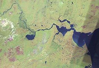 View of the area with Onemen Bay roughly in the middle. | |
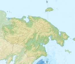 Onemen Bay Location in Chukotka Autonomous Okrug, Russia | |
| Location | Arctic |
| Coordinates | 64°42′58″N 176°43′43″E |
| River sources | Anadyr River |
| Ocean/sea sources | Anadyr Estuary Gulf of Anadyr, Bering Sea |
| Basin countries | Russia |
| Max. length | 40 km (25 mi) |
| Max. width | 5 km (3.1 mi) |
| Average depth | 20 m (66 ft) |
| Settlements | Tavayvaam |
Geography
The bay lies on the shores of the Anadyr Lowlands, with the mouth of the Anadyr River to the west, the Anadyr Estuary to the east, and the Kanchalan Bay, a small estuary part of the mouth of the Kanchalan River, on the northern part of the eastern end. The Velikaya River has its mouth to the south of the bay.[2]
gollark: The internet connection here has become slow and unstable. I hope this is fixed soon because having to stay at home without even working interweb connectivity would be horrible.
gollark: Also, OpenSSL still had Heartbleed for ages, sooo...
gollark: The law seems like it would basically require backdooring or removing it from some services.
gollark: Yes, it has been mentioned here already.
gollark: (NOTE: statements made ironically do not reflect my actual political views, but I'll never tell which are ironically made)
References
- Google Earth
- Onemen // Dictionary of the names of hydrographic objects of Russia and other countries - members of the CIS / ed. G.I. Donidze. - M .: Kartgeotsentr - Geodezizdat, 1999. - S. 323. - ISBN 5-86066-017-0 .
This article is issued from Wikipedia. The text is licensed under Creative Commons - Attribution - Sharealike. Additional terms may apply for the media files.