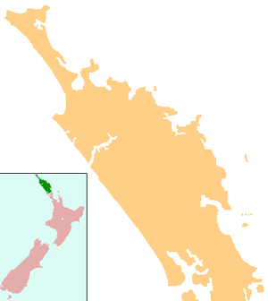
Omanaia
Omanaia (Māori: Ōmanaia) is a settlement in the Hokianga area of Northland, New Zealand. It is part of the Hokianga South statistical area, which covers the southern side of Hokianga Harbour between Rawene and Koutu. For demographics of this area, see Rawene.
Omanaia | |
|---|---|
 Omanaia | |
| Coordinates: 35°27′16″S 173°31′37″E | |
| Country | New Zealand |
| Region | Northland Region |
| District | Far North District |
The New Zealand Ministry for Culture and Heritage gives a translation of "place of Manaia" for Ōmanaia.[1]
In the 1830s, the Omanaia Maori chief Papahurihia led a nationalist movement to oppose the spread of Christianity through the Hokianga.[2]
The local Māhuri Marae and meeting house are a meeting place for the Ngāpuhi hapū of Ngāti Pākau and Te Māhurehure.[3][4]
Education
Omanaia School is a coeducational full primary (years 1-8) school[5] with a roll of 59 students as of March 2020.[6]
Notes
- "1000 Māori place names". New Zealand Ministry for Culture and Heritage. 6 August 2019.
- "TAONUI, Aperahama". Encyclopedia of New Zealand (1966).
- "Te Kāhui Māngai directory". tkm.govt.nz. Te Puni Kōkiri.
- "Māori Maps". maorimaps.com. Te Potiki National Trust.
- Education Counts: Omanaia School
- "New Zealand Schools Directory". New Zealand Ministry of Education. Retrieved 26 April 2020.
gollark: Yes, just make a million-volt transformer, I do not see what could possibly go wrong.
gollark: There's a thing for that for SDRs (https://www.rtl-sdr.com/tempestsdr-a-sdr-tool-for-eavesdropping-on-computer-screens-via-unintentionally-radiated-rf/), but it doesn't do color. I couldn't get it to run myself because of some weird driver-or-something problem.
gollark: boom += 1
gollark: It says here (Wikipedia) that thermal paste *sometimes* contains silicone but also metal compounds.
gollark: Apparently my mobile network blocks archive.org for some stupid reason. How wonderful.
This article is issued from Wikipedia. The text is licensed under Creative Commons - Attribution - Sharealike. Additional terms may apply for the media files.