Oklahoma State Highway 52
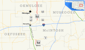
State Highway 52 (abbreviated SH-52) is two once-connected highways in the U.S. state of Oklahoma. There are no lettered spur routes from either of them.
| ||||
|---|---|---|---|---|
 | ||||
| Route information | ||||
| Maintained by ODOT | ||||
| Section 1 | ||||
| Length | 4.06 mi[1] (6.53 km) | |||
| South end | Hanna | |||
| North end | ||||
| Section 2 | ||||
| Length | 16.46 mi[2] (26.49 km) | |||
| South end | ||||
| North end | ||||
| Highway system | ||||
Oklahoma State Highway System
| ||||
Route description
Southern section
The southern SH-52 is a short, 4.06 miles (6.53 km)[1] state highway in McIntosh County, Oklahoma. It connects State Highway 9 to the town of Hanna.
History
At one time, at least as recently as 1972, the two sections of SH-52 were connected by a dirt section running from SH-9 to US-266. This section has since been decommissioned. [3]
Junction list
Southern section
The entire route is in McIntosh County.
| Location | mi[1] | km | Destinations | Notes | |
|---|---|---|---|---|---|
| Hanna | 0.00 | 0.00 | Countryside Road | Southern terminus | |
| | 4.06 | 6.53 | Northern terminus | ||
| 1.000 mi = 1.609 km; 1.000 km = 0.621 mi | |||||
Northern section
The entire route is in Okmulgee County.
| Location | mi[2] | km | Destinations | Notes | |
|---|---|---|---|---|---|
| | 0.00 | 0.00 | Southern terminus | ||
| Morris | 7.05 | 11.35 | |||
| | 16.46 | 26.49 | Northern terminus | ||
| 1.000 mi = 1.609 km; 1.000 km = 0.621 mi | |||||
gollark: I am not using GA. It's much more fun to read the webserver logs directly.
gollark: <@151391317740486657> Yep!
gollark: > All Arbitrary Points data is stored and processed only on your device. There is no serverside component whatsoever. If you don't like this regardless, you can bug me to implement an off switch, attempt to ignore it, or use Internet Explorer 6. Ideas for features and achievements and whatever else wanted and may be accepted. This is very easy to meddle with using the browser console, as I haven't tried to prevent that, but if you cheat all the time you may ruin any fun this might have brought.
gollark: Hax.
gollark: Perhaps. Or input a code you get from using potatOS.
References
- Oklahoma Department of Transportation (n.d.). Control Section Maps: McIntosh County (PDF) (Map) (2010–2011 ed.). Scale not given. Oklahoma City: Oklahoma Department of Transportation. Retrieved November 3, 2012.
- Oklahoma Department of Transportation (n.d.). Control Section Maps: Okmulgee County (PDF) (Map) (2010–2011 ed.). Scale not given. Oklahoma City: Oklahoma Department of Transportation. Retrieved November 3, 2012.
- McMahon, Martin. Terminus: SH-52 (North). Roadklahoma. 10 December 2002. URL accessed 28 May 2006.
This article is issued from Wikipedia. The text is licensed under Creative Commons - Attribution - Sharealike. Additional terms may apply for the media files.
