Ohio State Route 89
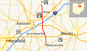
State Route 89 (SR 89) is a north–south state highway in the northern part of the U.S. state of Ohio. State Route 89 travels from its southern terminus at a T-intersection with State Route 95 approximately 5 miles (8 km) southeast of Hayesville to its northern terminus at a Y-intersection with State Route 58 nearly 3 miles (4.8 km) north of Polk.
| ||||
|---|---|---|---|---|
 | ||||
| Route information | ||||
| Maintained by ODOT | ||||
| Length | 18.60 mi[1] (29.93 km) | |||
| Existed | 1927[2][3]–present | |||
| Major junctions | ||||
| South end | ||||
| North end | ||||
| Location | ||||
| Counties | Ashland | |||
| Highway system | ||||
| ||||
Route description
All of State Route 89 is located within the eastern half of Ashland County. No segment of this highway is included within the National Highway System, a network of routes deemed most important for the economy, mobility and defense of the country.[4]
History
At the 1923 Ohio state highway renumbering, the State Route 89 designation was applied to the roadway between Aurora and Brimfield. This roadway was made part of State Route 43 in 1927 and the State Route 89 designation was assigned to the current route, which had previously been part of State Route 58.[5] In its original 1927 alignment, State Route 89 included a brief stretch of what is now State Route 95 between State Route 179 southeast of Hayesville and State Route 89's current southern terminus, along with the entirety of the current routing of State Route 89.[2][3] Five years after its inception, State Route 89 was extended to the southwest along the present routing of State Route 95 from State Route 179 to a new southern terminus at State Route 39 in Perrysville.[6][7]
In 1939, State Route 95 was extended northeasterly from its prior eastern terminus in Butler to the Wooster vicinity. Consequently, State Route 89 was scaled back to its present southern terminus, as all of the former State Route 89 southwest of that point became a part of the newly extended State Route 95. State Route 89 has maintained its present routing since that time.[8][9]
Major intersections
The entire route is in Ashland County.
| Location | mi[1] | km | Destinations | Notes | |
|---|---|---|---|---|---|
| Mohican Township | 0.00 | 0.00 | |||
| 3.64 | 5.86 | ||||
| Perry Township | 9.04 | 14.55 | |||
| Jackson Township | 12.15 | 19.55 | |||
| 13.50 | 21.73 | ||||
| 18.60 | 29.93 | ||||
| 1.000 mi = 1.609 km; 1.000 km = 0.621 mi | |||||
References
- Ohio Department of Transportation. "Technical Services Straight Line Diagrams" (PDF). Retrieved 2013-08-23.
- Map of Ohio Showing State Routes (MrSID) (Map). Cartography by ODHPW. Ohio Department of Highways and Public Works. August 1926. Retrieved February 6, 2011.
- Map of Ohio Showing State Highway System (MrSID) (Map). Cartography by ODHPW. Ohio Department of Highways and Public Works. June 1927. Retrieved February 6, 2011.
- National Highway System: Ohio (PDF) (Map). Federal Highway Administration. December 2003. Retrieved 2011-02-06.
- Map of Ohio Showing State Routes (PDF) (Map). Ohio Department of Transportation. 1923. Retrieved August 11, 2020.
- Map of Ohio Showing State Highway System (MrSID) (Map). Cartography by ODOH. Ohio Department of Highways. 1931. Retrieved February 6, 2011.
- Map of Ohio Showing State Highway System (MrSID) (Map). Cartography by ODOH. Ohio Department of Highways. 1932. Retrieved February 6, 2011.
- Official Ohio Highway Map (MrSID) (Map). Cartography by ODOH. Ohio Department of Highways. 1938. Retrieved February 6, 2011.
- Ohio Highway Map (MrSID) (Map). Cartography by ODOH. Ohio Department of Highways. 1939. Retrieved February 6, 2011.
