Ohio State Route 835
State Route 835 (SR 835) is an east–west state highway in Montgomery and Greene counties in Ohio, United States.
| ||||
|---|---|---|---|---|
 | ||||
| Route information | ||||
| Maintained by ODOT | ||||
| Length | 6.59 mi[1] (10.60 km) | |||
| Existed | 1987–present | |||
| Major junctions | ||||
| West end | ||||
| East end | ||||
| Location | ||||
| Counties | ||||
| Highway system | ||||
| ||||

Route description
.jpg)
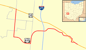
State Route 835 connects to U.S. Route 35 (US 35)on both ends, starting at that route's interchange with Woodman Drive (C-74) approximately 4½ miles east of Downtown Dayton. From there, the route occupies a portion of Woodman Drive for about 1.5 miles (2.4 km) south to Patterson Road on which the route heads east for about a mile. From there it turns north onto Research Boulevard which gradually turns to the east and follows to the route's terminus at the US 35 interchange with North Fairfield Road (C-9) in Beavercreek. SR 835 does not intersect with any other state highways.[1][2]
Major intersections
| County | Location | mi[1] | km | Destinations | Notes |
|---|---|---|---|---|---|
| Montgomery | Riverside | 0.00– 0.08 | 0.00– 0.13 | Western terminus. diamond interchange | |
| Greene | Beavercreek | 5.919– 6.586 | 9.526– 10.599 | Eastern terminus, interchange | |
| 1.000 mi = 1.609 km; 1.000 km = 0.621 mi | |||||
See also


References
- Ohio Department of Transportation. "Technical Services DESTAPE". Retrieved 2013-12-22.
- Google (2013-12-22). "Ohio State Route 835" (Map). Google Maps. Google. Retrieved 2013-12-22.
External links
![]()