Ohio State Route 767
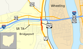
State Route 767 (SR 767) is a north–south state highway in the eastern portion of the U.S. state of Ohio. Currently, it is signed as an alternate route of SR 7.[2][3][4] Its southern terminus is at an exit ramp on SR 7 in Bridgeport. The route serves as a connector from northbound SR 7 to SR 7 Alternate, US 40, and US 250. The route's northern terminus is where these U.S. routes overlap eastbound to cross the Ohio River into West Virginia. SR 7A serves as a connector for all of these routes to I-70.
| ||||
|---|---|---|---|---|
 | ||||
| Route information | ||||
| Maintained by ODOT | ||||
| Length | 0.30 mi[1] (0.48 km) | |||
| Major junctions | ||||
| South end | ||||
| North end | ||||
| Location | ||||
| Counties | Belmont | |||
| Highway system | ||||
| ||||

Major intersections
The entire route is in Bridgeport, Belmont County.
| mi[1] | km | Destinations | Notes | ||
|---|---|---|---|---|---|
| 0.00– 0.08 | 0.00– 0.13 | Northbound exit from and southbound entrance to SR 7 | |||
| 0.11 | 0.18 | SR 7A (Howard Street) / South Lincoln Avenue | Western (southern) terminus of SR 7A | ||
| 0.30 | 0.48 | Eastern (northern) terminus of SR 7A | |||
| 1.000 mi = 1.609 km; 1.000 km = 0.621 mi | |||||
gollark: I managed no warnings even with -Weverything some time ago.
gollark: Also Cloudflare (they are hosted on my raspberry pi).
gollark: It's fine. In case of an issue with the main server, I can failover to the underpowered American one.
gollark: All websites are hosted on osmarks.net.
gollark: It's pleasantly crunchy.
References
- Ohio Department of Transportation. "Technical Services Straight Line Diagrams" (PDF). Retrieved July 7, 2013.
- "Northbound SR 767". Google Maps. Retrieved 2016-02-25.
- "Ramp to Northbound SR 7 and SR 767 Southbound". Google Maps. Retrieved 2016-02-25.
- "SR 767 Southbound". Google Maps. Retrieved 2016-02-25.
This article is issued from Wikipedia. The text is licensed under Creative Commons - Attribution - Sharealike. Additional terms may apply for the media files.