Ohio State Route 658
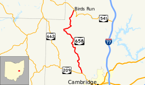
State Route 658 (SR 658) is a 11-mile-long (18 km) state highway in Guernsey County, Ohio. Located in the northwest quadrant of the county, it connects SR 209 in Adams Township (northwest of Cambridge) with SR 541 in Wheeling Township.
| ||||
|---|---|---|---|---|
 | ||||
| Route information | ||||
| Maintained by ODOT | ||||
| Length | 11.07 mi[1] (17.82 km) | |||
| Existed | 1937–present | |||
| Major junctions | ||||
| South end | ||||
| North end | ||||
| Location | ||||
| Counties | Guernsey | |||
| Highway system | ||||
| ||||
Route description
The two-lane road starts at a T-intersection with SR 209 in the northeastern corner of Adams Township. Through most of the route, the road passes through the Allegheny Plateau of the Appalachian Mountains; the elevations generally range between 800 and 1,000 feet (240 and 300 m) as it passes between small valleys formed by streams and the tops of hills. North from SR 209, SR 658 passes through forested areas ascending from the southern terminus to the top of a hill. After descending to cross Sarchet Run, the road ascends through two sharp curves to head into more open land on a ridge as it crosses into Knox Township. In Knox Township, SR 658 passes through the unincorporated settlement of Indian Camp and crosses Indian Camp Run and Dry Run. Near the Indian Camp Run Covered Bridge, SR 658 ascends another hill where it passes through a narrow strip of open land and the settlement of Flat Ridge. Beginning to near its northern terminus, the road crosses into Wheeling Township and descends to a flood plain of Wills Creek. In the community of Birds Run, the road passes open land, some homes, and a Baptist church. After crossing Wills Creek, SR 658 ends at an intersection with SR 541.[2][3]
History
SR 658 was designated on a road connecting SR 209 and what was then numbered SR 271 (now SR 541) in 1937.[4][5] Except for its transition from a gravel-paved road to a fully asphalt-paved road by 1958, the road has not experienced any major changes since its designation.[6][7]
Major intersections
The entire route is in Guernsey County.
| Location | mi[1] | km | Destinations | Notes | |
|---|---|---|---|---|---|
| Adams Township | 0.00 | 0.00 | |||
| Wheeling Township | 11.07 | 17.82 | |||
| 1.000 mi = 1.609 km; 1.000 km = 0.621 mi | |||||
References
- "DESTAPE - Guernsey County" (PDF). Ohio Department of Transportation. June 24, 2015. Retrieved January 1, 2016.
- Google (January 1, 2016). "Ohio State Route 658" (Map). Google Maps. Google. Retrieved January 1, 2016.
- Guernsey County (PDF) (Map). ODOT. June 2012. Retrieved January 1, 2016.
- Map of Ohio Showing State Routes (MrSID) (Map). Cartography by ODHPW. Ohio Department of Highways and Public Works. 1936. Retrieved 2013-10-05.
- Map of Ohio Showing State Routes (MrSID) (Map). Cartography by ODHPW. ODHPW. 1937. Retrieved 2013-10-05.
- Ohio Highway Map 1957 (MrSID) (Map). Cartography by George J. Thormyer, Acting Director. ODOH. 1957. Retrieved September 23, 2013.
- 1958-1959 Official Ohio Highway Map (MrSID) (Map). Cartography by Charles M. Noble, Director of Highways. ODOH. 1958. Retrieved September 23, 2013.
