Ohio State Route 651
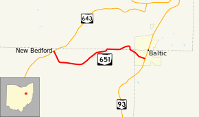
State Route 651 (SR 651) is a short state highway located in the vicinity of the tripoint of Coshocton, Holmes, and Tuscarawas Counties in Ohio. The route is 3.98 miles (6.41 km) long and is signed east–west. Its western terminus is at SR 643 in the unincorporated community of New Bedford (within Crawford Township) and its eastern terminus is at SR 93 in the village of Baltic.
| ||||
|---|---|---|---|---|
 | ||||
| Route information | ||||
| Maintained by ODOT | ||||
| Length | 3.98 mi[1] (6.41 km) | |||
| Existed | 1939–present | |||
| Major junctions | ||||
| West end | ||||
| East end | ||||
| Location | ||||
| Counties | Coshocton, Holmes, Tuscarawas | |||
| Highway system | ||||
| ||||
Route description
SR 651 begins at a four-way stop-controlled intersection with SR 643 and County Road 12 in the center of New Bedford, an unincorporated community. The route heads southeast from the intersection through a mix of light commercial and residential buildings. Upon exiting New Bedford, the route travels in a more easterly direction through farmland with occasional houses. At 2.4 miles (3.9 km) into the route, the route straddles the Coshocton–Holmes County line for about 0.46 miles (0.74 km). The route then dips fully into Holmes County before reentering Coshocton County briefly. It then enters Tuscarawas County and the village of Baltic on Main Street. Main Street and SR 651 descend into the center of Baltic, crossing a Wheeling and Lake Erie railroad, and ending at an intersection with SR 93 (also known as Ray Street). East Main Street continues ahead from this point.[1][2]
History
SR 651 was first designated in 1939, but was much longer at that time that its present routing.[3][4] The 1939 route included all of the modern-day SR 651, but the route then headed east and later northeast out of Baltic on Tuscarawas County Road 52 to Ragersville. The route then followed County Road 52 east to what was then US 21 just southwest of New Philadelphia.[5][4] The route between New Bedford and Baltic was a gravel road at its inception into the state highway system while most of the route between Baltic and New Philadelphia was paved.[4] By 1942, the Baltic-New Philadelphia segment was downgraded to county roads leaving the current New Bedford-Baltic segment the only section of SR 651.[6][7] No major changes have occurred to the route since then.
Major intersections
| County | Location | mi[1] | km | Destinations | Notes | |||
|---|---|---|---|---|---|---|---|---|
| Coshocton | Crawford Township | 0.00 | 0.00 | |||||
| Holmes |
No major junctions | |||||||
| Coshocton |
No major junctions | |||||||
| Tuscarawas | Baltic | 3.98 | 6.41 | |||||
| 1.000 mi = 1.609 km; 1.000 km = 0.621 mi | ||||||||
References
- Ohio Department of Transportation. "Technical Services Straight Line Diagrams". Retrieved October 24, 2013.
- Google (October 25, 2013). "Ohio State Route 651" (Map). Google Maps. Google. Retrieved October 25, 2013.
- Official 1938 Ohio Highway Map (MrSID) (Map). Cartography by John Jaster, Jr., Director. Ohio Department of Highways. 1938. Retrieved August 19, 2013.
- Ohio Highway Map 1939 (MrSID) (Map). Cartography by Robt. S. Beightler, Director. ODOH. 1939. Retrieved August 19, 2013.
- Tuscarawas County (PDF) (Map). ODOT. June 2012. Retrieved October 25, 2013.
- Ohio Highway Map 1941 (MrSID) (Map). Cartography by H.G. Sours, Director. ODOH. 1941. Retrieved August 19, 2013.
- Ohio Highway Map 1942 (MrSID) (Map). Cartography by H.G. Sours, Director. ODOH. 1942. Retrieved August 19, 2013.
