Ohio State Route 598
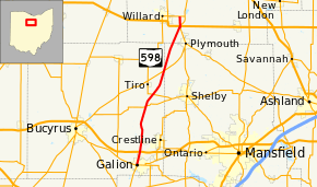
State Route 598 (SR 598) is a 23.43-mile-long (37.71 km) north–south state highway in the northern portion of the U.S. state of Ohio. The southern terminus of SR 598 is at a signalized intersection where it meets SR 19, SR 61 and SR 309 in Galion. Its northern terminus is at SR 103 nearly 1.75 miles (2.82 km) east of Willard.
| ||||
|---|---|---|---|---|
 | ||||
| Route information | ||||
| Maintained by ODOT | ||||
| Length | 23.43 mi[1][2][3] (37.71 km) | |||
| Existed | April 15, 1937[4]–present | |||
| Major junctions | ||||
| South end | ||||
| {{plainlist }} | ||||
| North end | ||||
| Location | ||||
| Counties | Crawford, Richland, Huron | |||
| Highway system | ||||
| ||||

Route description

Along its path, SR 598 travels through eastern Crawford County, northwestern Richland County and southwestern Huron County. SR 598 is not included as a part of the National Highway System (NHS). The NHS is a network of routes identified as being most important for the economy, mobility and defense of the nation.[5]
History
SR 598 was applied on April 15, 1937 to a former county road.[4] The highway was originally routed along its present alignment from its southern terminus in Galion to its junction with SR 98 northeast of Tiro.[6][7] One year later, SR 598 was extended to the northeast along a previously un-numbered roadway, then northerly along a brief overlap of SR 61 and a short state highway that had carried the SR 289 designation to its current northern terminus at what was then the predecessor to SR 103, SR 194.[8]
Major intersections
| County | Location | mi[1][2][3] | km | Destinations | Notes | |||
|---|---|---|---|---|---|---|---|---|
| Crawford | Galion | 0.00 | 0.00 | |||||
| Jefferson Township | 1.99 | 3.20 | Interchange | |||||
| Vernon Township | 8.95 | 14.40 | Southern end of SR 96 concurrency | |||||
| 9.08 | 14.61 | Northern end of SR 96 concurrency | ||||||
| 11.00 | 17.70 | |||||||
| Auburn Township | 14.91 | 24.00 | ||||||
| Richland |
No major junctions | |||||||
| Huron | New Haven Township | 21.86 | 35.18 | Southern end of SR 61 concurrency | ||||
| 21.99 | 35.39 | |||||||
| 22.25 | 35.81 | Northern end of SR 61 concurrency | ||||||
| 23.43 | 37.71 | |||||||
1.000 mi = 1.609 km; 1.000 km = 0.621 mi
| ||||||||
See also
References
- Ohio Department of Transportation. "Technical Services Straight Line Diagrams: SR 598, Crawford County" (PDF). Archived from the original (PDF) on 2012-03-25. Retrieved 2011-06-04.
- Ohio Department of Transportation. "Technical Services Straight Line Diagrams: SR 598, Richland County" (PDF). Archived from the original (PDF) on 2012-03-25. Retrieved 2011-06-04.
- Ohio Department of Transportation. "Technical Services Straight Line Diagrams: SR 598, Huron County" (PDF). Archived from the original (PDF) on 2012-03-25. Retrieved 2011-06-04.
- "Route Numbers of Crawford County Highways Changed". The Telegraph-Forum. Bucyrus, Ohio. April 15, 1937. p. 10. Retrieved June 29, 2020 – via Newspapers.com.

- National Highway System: Ohio (PDF) (Map). Federal Highway Administration. December 2003. Retrieved 2011-06-04.
- Official Ohio Highway Map (MrSID) (Map). Cartography by ODOH. Ohio Department of Highways. 1936. Retrieved 2011-06-04.
- Official Ohio Highway Map (MrSID) (Map). Cartography by ODOH. Ohio Department of Highways. 1937. Retrieved 2011-06-04.
- Official Ohio Highway Map (MrSID) (Map). Cartography by ODOH. Ohio Department of Highways. 1938. Retrieved 2011-06-04.
External links
![]()