Ohio State Route 556
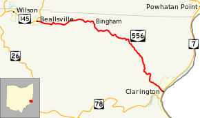
State Route 556 (SR 556) is an east–west state highway located in the southeastern portion of the U.S. state of Ohio. State Route 556 runs from its western terminus at State Route 145 in Beallsville to its eastern terminus at a T-intersection with State Route 7 in Clarington, just a short distance from the western banks of the Ohio River.
| ||||
|---|---|---|---|---|
 | ||||
| Route information | ||||
| Maintained by ODOT | ||||
| Length | 13.24 mi[1] (21.31 km) | |||
| Existed | 1937[2][3]–present | |||
| Major junctions | ||||
| West end | ||||
| East end | ||||
| Location | ||||
| Counties | Monroe | |||
| Highway system | ||||
| ||||

Route description
State Route 556 runs entirely within the northern part of Monroe County. This highway is not incorporated as a part of the National Highway System, a system of routes identified as being most important for the economy, mobility and defense of the country.[4]
History
The State Route 556 designation was assigned in 1937. It has utilized the same alignment between Beallsville and Clarington through northern Monroe County since its designation. No major changes have taken place to State Route 556's routing since it was created. The only thing that has changed with respect to this route in its history is the route at its western terminus. What is now a part of State Route 145 was designated as State Route 9 when State Route 556 was established.[2][3]
Major intersections
The entire route is in Monroe County.
| Location | mi[1] | km | Destinations | Notes | |
|---|---|---|---|---|---|
| Beallsville | 0.00 | 0.00 | |||
| Clarington | 13.24 | 21.31 | |||
| 1.000 mi = 1.609 km; 1.000 km = 0.621 mi | |||||
References
- Ohio Department of Transportation. "Technical Services Straight Line Diagrams" (PDF). Retrieved 2013-08-03.
- Official Ohio Highway Map (MrSID) (Map). Cartography by ODOH. Ohio Department of Highways. 1936. Retrieved 2011-02-01.
- Official Ohio Highway Map (MrSID) (Map). Cartography by ODOH. Ohio Department of Highways. 1937. Retrieved 2011-02-01.
- National Highway System: Ohio (PDF) (Map). Federal Highway Administration. December 2003. Retrieved 2011-02-01.