Ohio State Route 523
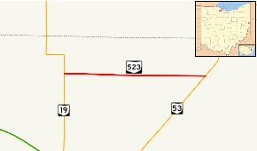
Ohio State Route 523 (OH 523) is a state highway in North Central Ohio. A short connector route, OH 523 links OH 19 at its western terminus with OH 53 at its eastern terminus. OH 523's intersection with OH 53 is located less than 4 miles (6.4 km) northeast of the OH 53 exit off of I-80/I-90/Ohio Turnpike.
| ||||
|---|---|---|---|---|
 | ||||
| Route information | ||||
| Maintained by ODOT | ||||
| Length | 3.79 mi[1] (6.10 km) | |||
| Existed | 1939[2]–present | |||
| Major junctions | ||||
| West end | ||||
| East end | ||||
| Location | ||||
| Counties | Sandusky | |||
| Highway system | ||||
| ||||
Route description

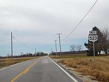
OH 523 begins at an intersection with OH 19 and County Road 143 in Rice Township. The route heads eastward along a flat terrain, passing a couple of homes and then progressing through fields and nothing else around it. There is an intersection with Fangboner Road (Township Road 166) soon after, but there is no intersections with other state-maintained roads afterwards. County Road 170 comes soon after, crossing at about the midpoint of the highway.[3]
As the road progresses eastward, there are intersections with county roads 174 and 182 and one township road. OH 523 terminates at an intersection with OH 53 in Rice Township, nearly 4 miles (6.4 km) to the east of OH 19.[3]
History
OH 523 was assigned to its current routing in 1939, and has not seen any changes of significance since its inception.[2][4]
Junctions
The entire route is in Rice Township, Sandusky County.
| mi[1] | km | Destinations | Notes | ||
|---|---|---|---|---|---|
| 0.00 | 0.00 | ||||
| 3.79 | 6.10 | ||||
| 1.000 mi = 1.609 km; 1.000 km = 0.621 mi | |||||
References
- Ohio Department of Transportation. "Technical Services Straight Line Diagrams" (PDF). Retrieved August 3, 2013.
- Ohio State Map (Map). Ohio Department of Transportation. 1939.
- Google (2008-06-28). "overview map of OH 523" (Map). Google Maps. Google. Retrieved 2008-06-28.
- Ohio State Map (Map). Ohio Department of Transportation. 1938.
