Ohio State Route 48
State Route 48 (SR 48) is a north–south highway in Ohio that runs from SR 132 near Goshen to SR 66 near Houston, passing through Dayton.
| |||||||
|---|---|---|---|---|---|---|---|
| U.S.A.F. Pararescue Memorial Parkway[1][2] | |||||||
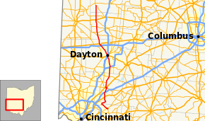 Route of SR 48 highlighted in red | |||||||
| Route information | |||||||
| Maintained by ODOT | |||||||
| Length | 83.03 mi[3] (133.62 km) | ||||||
| Existed | 1926–present | ||||||
| Major junctions | |||||||
| South end | |||||||
| North end | |||||||
| Location | |||||||
| Counties | Clermont, Warren, Montgomery, Miami, Shelby | ||||||
| Highway system | |||||||
| |||||||

History
In the early 20th century, SR 48 was assigned to completely unrelated routes within the state. From 1923 to 1927, it was the designation given to Barnesville–Hendrysburg, Barnesville–Woodsfield, and Woodsfield–Sistersville roads in eastern Ohio, now designated SR 800. Present-day SR 48 was previously signed as SR 50, and before that as Dayton–Covington and Dayton–Lebanon roads. (See 1923 Ohio state highway renumbering and 1927 Ohio state highway renumbering).
In I Love Lucy episode #111, "First Stop", the Ricardos and the Mertzes travel this route, although they were headed to Cincinnati.
On February 15, 2005, Governor Bob Taft signed Senate Bill 156, which designated SR 48 as U.S.A.F. Pararescue Memorial Parkway.[4] The route runs near the hometowns of four pararescuemen who were killed in action: William H. Pitsenbarger of Piqua, Sgt. Jim Locker of Sidney, Master Sgt. William McDaniel II of Greenville, and Airman 1st Class James Pleiman of Russia.[1][5] Memorial markers are installed as far south as Goshen Township in Clermont County.[2]
In 2010, SR 48 within the Loveland city limits was additionally designated as Captain Seth Mitchell Memorial Highway.[6] Mitchell, a Loveland resident, served in the War in Afghanistan and died in a helicopter crash in Helmand Province on October 26, 2009.[7]
Major intersections
| County | Location | mi[3] | km | Destinations | Notes |
|---|---|---|---|---|---|
| Clermont | Goshen Township | 0.00 | 0.00 | ||
| 0.98 | 1.58 | Southern end of SR 28 overlap | |||
| 1.38 | 2.22 | Northern end of SR 28 overlap | |||
| Warren | Hamilton Township | 13.43 | 21.61 | ||
| South Lebanon | 16.67 | 26.83 | I-71 exit 28 | ||
| Lebanon | 18.31 | 29.47 | Turtle Creek–Union Road, Deerfield Road | Interchange | |
| 20.27 | 32.62 | Southern end of SR 123 overlap | |||
| 21.50 | 34.60 | Southern end of US 42 overlap | |||
| 21.65 | 34.84 | Northern end of SR 123 overlap | |||
| 21.72 | 34.95 | Northern end of US 42 overlap | |||
| Clear Creek Township | 25.10 | 40.39 | |||
| 23.08 | 37.14 | ||||
| Montgomery | Centerville | 35.61 | 57.31 | Southern end of SR 725 overlap | |
| 36.68 | 59.03 | Northern end of SR 725 overlap | |||
| 36.83 | 59.27 | I-675 south exit 4, north exits 4A-B | |||
| Dayton | 44.28 | 71.26 | Directional split begins; northbound traffic continues on S. Patterson Boulevard, S. Jefferson Street, and E. Monument Avenue | ||
| 44.55 | 71.70 | ||||
| 45.51 | 73.24 | Directional split ends; southbound traffic continues on W. Monument Avenue, Ludlow Street, and Stout Street | |||
| 45.98 | 74.00 | I-75 exits 54A–B | |||
| Englewood | 53.73 | 86.47 | I-70 exit 29 | ||
| 54.48 | 87.68 | Southern end of US 40 overlap | |||
| 54.51 | 87.73 | Northern end of US 40 overlap | |||
| Miami | West Milton | 61.70 | 99.30 | Southern end of SR 571 overlap | |
| 61.73 | 99.34 | Northern end of SR 571 overlap | |||
| Union Township | 63.77 | 102.63 | Southern end of SR 55 overlap | ||
| Ludlow Falls | 64.24 | 103.38 | Northern end of SR 55 overlap | ||
| Pleasant Hill | 67.84 | 109.18 | |||
| Covington | 72.24 | 116.26 | Southern end of SR 41 overlap | ||
| 72.71 | 117.02 | Northern end of SR 41 overlap | |||
| Newberry Township | 75.78 | 121.96 | |||
| Shelby | Houston | 83.03 | 133.62 | ||
1.000 mi = 1.609 km; 1.000 km = 0.621 mi
| |||||
SR 48-T
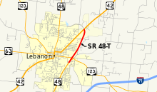
State Route 48 Temporary (SR 48-T, also called Future SR 48 and Bypass 48[8][9]) is a 1.87-mile-long (3.01 km)[10] partial bypass of Lebanon running from the SR 48 / SR 123 interchange to an intersection of US 42 and Miller Road. The four-lane divided roadway is a northern continuation of a divided highway segment of SR 48. The route was created by 1971 when a high-speed bypass of Lebanon was created.[11][12] SR 48-T is not signed as such; the northbound direction is signed as "To US 42 north" and the southbound direction is signed as "To SR 48 south."[13]
References
- Deeter, Judy. "William H. Pitsenbarger: A Hero of Piqua and America". This Local Life. Troy, Ohio: My Miami County. Retrieved July 7, 2019.
- Nguyen, Minh (October 16, 2018). "image by 1ec5". Mapillary. Retrieved July 7, 2019.
- "Roadway Description Inventory Report - DESTAPE". Ohio Department of Transportation. March 6, 2017. Retrieved June 24, 2017. Cite journal requires
|journal=(help)- Clermont County (PDF)
- Warren County (PDF)
- Montgomery County (PDF)
- Miami County (PDF)
- Shelby County (PDF)
- "5533.62 U.S.A.F. Pararescue memorial highway". Ohio Revised Code. LAW Writer. May 18, 2005. Retrieved July 13, 2019.
- "Ohio Governor Signs 'PJ Parkway' Law" (PDF). Journal of Special Operations Medicine. Hurlburt Field, Florida: Joint Special Operations University. 6 (2): 55. Spring 2006. ISSN 1553-9768. Retrieved July 7, 2019.
- Ohio Rev. Code §5533.621. "Captain Seth Mitchell Memorial Highway".
- Houck, Jeanne (February 17, 2010). "The route to immortality". The Loveland Herald. 91 (52). The Community Press. p. A1.
- "Warren County 24-Hour Average Traffic County" (PDF). ODOT. 1982. pp. 2, 3. Retrieved January 7, 2014.
- Lebanon, OH and Vicinity (Map). Hampton Publishing Co. Retrieved January 7, 2014.
- ODOT. "Technical Services Straight Line Diagrams: SR 48-T" (PDF). Retrieved January 7, 2014.
- 1969 Official Ohio Highway Map (MrSID) (Map). Cartography by P.E. Masheter, Director. Ohio Department of Highways. 1969. Retrieved September 22, 2013.
- 1971 Ohio Highway Map (MrSID) (Map). Cartography by J. Phillip Richley, Director. ODOH. 1971. Retrieved August 19, 2013.
- Google (January 7, 2014). "Overview of SR 48-T" (Map). Google Maps. Google. Retrieved January 7, 2014.
External links
| Wikimedia Commons has media related to Ohio State Route 48. |