Ohio State Route 153
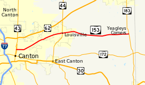
State Route 153 (SR 153) is a 14.69-mile (23.64 km) long east–west state highway in the northeastern portion of the U.S. state of Ohio. The western terminus of SR 153 is at a signalized intersection with southbound SR 43 in Canton, along a stretch of SR 43 where that highway is divided into a one-way couplet. SR 153 has its eastern endpoint at SR 183 nearly 4 miles (6.4 km) south of Alliance.
| ||||
|---|---|---|---|---|
 | ||||
| Route information | ||||
| Maintained by ODOT | ||||
| Length | 14.69 mi[1] (23.64 km) | |||
| Existed | 1932[2][3]–present | |||
| Major junctions | ||||
| West end | ||||
| East end | ||||
| Location | ||||
| Counties | Stark | |||
| Highway system | ||||
| ||||

Route description
All of SR 153 is situated within the eastern half of Stark County. No part of this state highway is included as a part of the National Highway System (NHS). The NHS is a network of routes determined to be most important for the economy, mobility and defense of the nation.[4]
History
The SR 153 designation was established in 1932. Its original routing consisted of the portion of the existing alignment of SR 153 between its western terminus at SR 43 in Canton and its junction with SR 44 in Louisville. SR 153 replaced what was a portion of SR 44 before that highway was re-routed to continue due south from Louisville toward East Canton.[2][3] In 1937, SR 153 was extended east from Louisville to its present eastern terminus at SR 183, which at the time carried the SR 80 designation. The extension utilized a county-maintained roadway.[5][6]
Major intersections
The entire route is in Stark County.
| Location | mi[1] | km | Destinations | Notes | |
|---|---|---|---|---|---|
| Canton | 0.00 | 0.00 | Western terminus at one-way street; road continues as 12th Street NW | ||
| 0.10 | 0.16 | One-way street | |||
| Louisville | 6.25 | 10.06 | |||
| Washington Township | 14.69 | 23.64 | Eastern terminus; road continues as Louisville Street | ||
| 1.000 mi = 1.609 km; 1.000 km = 0.621 mi | |||||
References
- Ohio Department of Transportation. "Technical Services Straight Line Diagrams: SR 153, Stark County" (PDF). Archived from the original (PDF) on 2011-10-08. Retrieved 2008-10-27.
- Map of Ohio Showing State Highway System (MrSID) (Map). Cartography by ODOH. Ohio Department of Highways. 1931. Retrieved 2011-04-21.
- Map of Ohio Showing State Highway System (MrSID) (Map). Cartography by ODOH. Ohio Department of Highways. 1932. Retrieved 2011-04-21.
- National Highway System: Ohio (PDF) (Map). Federal Highway Administration. December 2003. Retrieved 2011-04-20.
- Official Ohio Highway Map (MrSID) (Map). Cartography by ODOH. Ohio Department of Highways. 1936. Retrieved 2011-04-21.
- Official Ohio Highway Map (MrSID) (Map). Cartography by ODOH. Ohio Department of Highways. 1937. Retrieved 2011-04-21.