North Carolina Highway 522
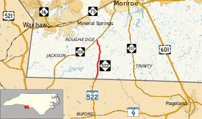
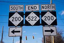
North Carolina Highway 522 (NC 522) is a primary state highway in the U.S. state of North Carolina. The highway runs north–south from the South Carolina state line, near Sapps Crossroads to NC 200 in Roughedge, entirely in Union County.
| ||||
|---|---|---|---|---|
| Rocky River Road | ||||
 | ||||
| Route information | ||||
| Maintained by NCDOT | ||||
| Length | 5.8 mi[1] (9.3 km) | |||
| Existed | 1951[2]–present | |||
| Major junctions | ||||
| South end | ||||
| North end | ||||
| Location | ||||
| Counties | Union | |||
| Highway system | ||||
| ||||
Route description

NC 522 is a short 5.84-mile (9.40 km) two-lane rural highway in Union County, passing through an area of mixed forest and farmland.[3]
History
Established as a new primary routing around 1951, it is complementary extension of SC 522; unchanged since.[2][4]
Junction list
The entire route is in Union County.
| Location | mi[1] | km | Destinations | Notes | |
|---|---|---|---|---|---|
| | 0.0 | 0.0 | South Carolina state line | ||
| Roughedge | 5.8 | 9.3 | |||
| 1.000 mi = 1.609 km; 1.000 km = 0.621 mi | |||||
gollark: This is very ethical.
gollark: You can fix climate change by deploying self-replicating nanomachines to dissemble atmospheric carbon dioxide into solid carbon and oxygen.
gollark: Birds are NOT real.
gollark: There are entirely too many weird interacting trends going on right now which make it hard to predict much, not that that was ever very easy.
gollark: The best estimate I'm aware of is that humanity has a 1/6 chance of ceasing to exist within a century, although this says nothing about societal collapse which doesn't wipe out everyone.
References
- Google (February 29, 2016). "North Carolina Highway 522" (Map). Google Maps. Google. Retrieved February 29, 2016.
- "NCRoads.com: N.C. 522". Archived from the original on June 4, 2011. Retrieved 2011-06-26.
- Union County, North Carolina (PDF) (Map). North Carolina Department of Transportation. December 2015. Retrieved March 7, 2016.
- North Carolina County Road Survey 1953 (PDF) (Map). Cartography by NCSHC / U.S. Bureau of Public Roads. North Carolina State Highway Commission. 1953. Retrieved March 7, 2016.
External links

- NCRoads.com: N.C. 522
This article is issued from Wikipedia. The text is licensed under Creative Commons - Attribution - Sharealike. Additional terms may apply for the media files.
