North Carolina Highway 381
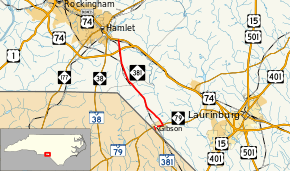
North Carolina Highway 381 (NC 381) is a primary state highway in the U.S. state of North Carolina. The highway connects the cities of Hamlet and Gibson.
| ||||
|---|---|---|---|---|
 | ||||
| Route information | ||||
| Maintained by NCDOT | ||||
| Length | 10.6 mi[1] (17.1 km) | |||
| Existed | 1940–present | |||
| Major junctions | ||||
| South end | ||||
| North end | ||||
| Location | ||||
| Counties | Scotland, Richmond | |||
| Highway system | ||||
| ||||

Route description
NC 381 is a two-lane rural highway that traverses 10.6 miles (17.1 km) from the South Carolina state line in Gibson to U.S. Route 74 Business near Hamlet. The highway is flanked with farms and has little traffic.
History
Established in 1940 as a renumbering of NC 78 when the route was extended to the South Carolina state line, connecting with SC 381; remained unchanged since inception.[2]
Junction list
| County | Location | mi[1] | km | Destinations | Notes |
|---|---|---|---|---|---|
| Scotland | Gibson | 0.0 | 0.0 | South Carolina state line | |
| 0.4 | 0.64 | South end of NC 79 overlap | |||
| 1.2 | 1.9 | North end of NC 79 overlap | |||
| Richmond | | 9.6 | 15.4 | Exit 320 (US 74) | |
| | 10.6 | 17.1 | |||
1.000 mi = 1.609 km; 1.000 km = 0.621 mi
| |||||
gollark: <@186486131565527040> Try `print(common)` at some point to see if it loaded.
gollark: You should have used require.
gollark: <@186486131565527040> I'm relatively sure you cannot actually store items on CC disks.
gollark: Ah.
gollark: And?
References
- Google (June 16, 2013). "North Carolina Highway 381" (Map). Google Maps. Google. Retrieved June 16, 2013.
- North Carolina Primary Highway System (PDF) (Map). Cartography by NCSHC. North Carolina State Highway and Public Works Commission. 1940. Retrieved December 24, 2015.
External links

- NCRoads.com: N.C. 381
This article is issued from Wikipedia. The text is licensed under Creative Commons - Attribution - Sharealike. Additional terms may apply for the media files.