North Carolina Highway 225
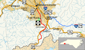
North Carolina Highway 225 (NC 225) is a 10.7-mile (17.2 km) route running from U.S. Route 25 (US 25), near the South Carolina state line to Hendersonville. It crosses over US 25 once before ending. It runs through East Flat Rock and near Lake Summit.
| ||||
|---|---|---|---|---|
 | ||||
| Route information | ||||
| Maintained by NCDOT | ||||
| Length | 10.7 mi[1] (17.2 km) | |||
| Existed | 1997–present | |||
| Major junctions | ||||
| South end | ||||
| North end | ||||
| Location | ||||
| Counties | Henderson | |||
| Highway system | ||||
| ||||
Route description

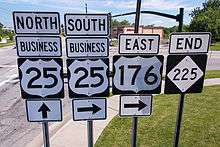
NC 225 is a two-lane rural highway that travels along a former routing of US 25 in Henderson County. Beginning along Bobs Creek Road and US 25 (exit 1), it goes east and then north along Old US Highway 25. Crossing the Green River, it enters the community of Tuxedo, wedged between US 25 and Lake Summit. At Zirconia, it crosses underneath US 25 (exit 5) continuing north through the village of Flat Rock. In Hendersonville, it ends at the intersection of South Main Street (US 25 Business) and Spartanburg Highway (US 176). This point also marks the terminus for US 176.[1]
With exception to Bobs Creek Road, NC 225 overlaps what was formally the Dixie Highway (1915-1927).
NC 225 is part of one scenic byway in the state (indicated by a Scenic Byways sign).[2] Historic Flat Rock Scenic Byway is an 8.3-mile (13.4 km) byway from Pinnacle Mountain Road (SR 1114) to Highland Lake Road (SR 1783). It is noted for its views of nearby Glassy and McAlpin mountains and access to the Carl Sandburg Home National Historic Site, the Flat Rock Playhouse and the Flat Rock Historic District.[2]
History
Established in 1997, NC 225 follows the old US 25 alignment through Tuxedo, when US 25 was placed on new bypass route in 1981. At Zirconia, NC 225 traveled east as a new primary routing along a super two connector between US 25 and Interstate 26 (I-26).[3][4] In 2003, and after expansion of the Super two into a four-lane freeway, US 25 was rerouted east of Zirconia towards I-26. As a result, NC 225 was rerouted along US 25 old alignment north of Zirconia to its current northern terminus at US 176/US 25 Business in Hendersonville.[5]
Junction list
The entire route is in Henderson County.
| Location | mi[1] | km | Destinations | Notes | |
|---|---|---|---|---|---|
| | 0.0– 0.1 | 0.0– 0.16 | Exit 1 (US 25) | ||
| Zirconia | 4.5– 4.9 | 7.2– 7.9 | Exit 5 (US 25) | ||
| Hendersonville | 10.7 | 17.2 | Western terminus of US 176 | ||
| 1.000 mi = 1.609 km; 1.000 km = 0.621 mi | |||||
References
- Google (February 22, 2016). "North Carolina Highway 225" (Map). Google Maps. Google. Retrieved February 22, 2016.
- "North Carolina Scenic Byways" (PDF). North Carolina Department of Transportation. Archived from the original (PDF) on October 20, 2012. Retrieved December 2, 2012.
- "Route Change (1997-10-31)" (PDF). North Carolina Department of Transportation. October 31, 1997. p. 2. Retrieved May 3, 2015.
- Henderson County, North Carolina (PDF) (Map). North Carolina Department of Transportation. September 1, 1999. p. 130. Retrieved February 22, 2016.
- "Route Change (2003-09-15)" (PDF). North Carolina Department of Transportation. September 15, 2003. p. 3. Retrieved May 3, 2015.
External links

- NCRoads.com: N.C. 225
