North Carolina Highway 198
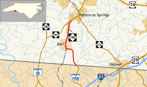
North Carolina Highway 198 (NC 198) is a primary state highway in the U.S. state of North Carolina. It connects the town of Earl with the rest of Cleveland County.
| ||||
|---|---|---|---|---|
| Blacksburg Road | ||||
 | ||||
| Route information | ||||
| Maintained by NCDOT | ||||
| Length | 4.3 mi[1] (6.9 km) | |||
| Existed | 1952–present | |||
| Major junctions | ||||
| South end | ||||
| North end | ||||
| Location | ||||
| Counties | Cleveland | |||
| Highway system | ||||
| ||||

Route description
A two-lane rural highway, it traverses 4.3 miles (6.9 km), starting at the South Carolina state line at Buffalo Creek, through the town of Earl, ending at NC 180, south of Patterson Springs.
History
Established in 1952, the route has not changed since.[2]
Junction list
The entire route is in Cleveland County.
| Location | mi[1] | km | Destinations | Notes | |
|---|---|---|---|---|---|
| | 0.0 | 0.0 | Southern terminus; South Carolina state line | ||
| | 4.3 | 6.9 | Northern terminus | ||
| 1.000 mi = 1.609 km; 1.000 km = 0.621 mi | |||||
gollark: Yes, I noticed that with my laptop versus my phone, it's weird.
gollark: What?
gollark: Oh, they """left""".
gollark: Greetings, mortal.
gollark: Bismuth.
References
- Google (2012-01-06). "North Carolina Highway 198" (Map). Google Maps. Google. Retrieved 2012-01-06.
- "NCRoads.com: N.C. 198". Retrieved 2012-01-06.
This article is issued from Wikipedia. The text is licensed under Creative Commons - Attribution - Sharealike. Additional terms may apply for the media files.