North Carolina Highway 171
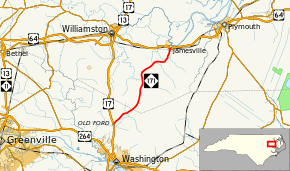
North Carolina Highway 171 (NC 171) is a primary state highway in the U.S. state of North Carolina. It utilized as a connector route running from US 17 in Old Ford between Washington and Williamston to US 64 Business in Jamesville.
| ||||
|---|---|---|---|---|
 | ||||
| Route information | ||||
| Maintained by NCDOT | ||||
| Length | 17.2 mi[1] (27.7 km) | |||
| Existed | 1936–present | |||
| Major junctions | ||||
| South end | ||||
| North end | ||||
| Location | ||||
| Counties | Beaufort, Martin | |||
| Highway system | ||||
| ||||
Route description
Starting from US 17, in Old Ford, this two-lane rural highway travels through the farmland of Beaufort and Martin Counties, ending in downtown Jamesville at US 64 Business.[1]
History
Established as a new primary routing in 1936 and has not changed since.[2] However, it had existed previously in the late 1920s to late 1934 from Lenoir to Edgemont; it was replaced by NC 90.[3]
Junction list
| County | Location | mi[1] | km | Destinations | Notes |
|---|---|---|---|---|---|
| Beaufort | Old Ford | 0.0 | 0.0 | Southern terminus | |
| Martin | Jamesville | 16.9 | 27.2 | ||
| 17.2 | 27.7 | Northern terminus | |||
| 1.000 mi = 1.609 km; 1.000 km = 0.621 mi | |||||
gollark: No, the ads could just say "allow access from any domain".
gollark: LocalStorage and IndexedDB would be replaced with WebSQL or something, which is just an interface to SQLite.
gollark: It'll send your cookies with it and stuff, so if you could see the response it would be a horrible security problem.
gollark: Yes. The situation now is that browsers will happily send requests from one origin to another, but only if it's a GET or POST request, not allow custom headers with it, and, critically, do bizarre insane stuff to avoid letting code see the *response*.
gollark: Oh, and unify ServiceWorker and WebWorker and SharedWorker and whatever into some sort of nicer "background task" API.
References
- Google (July 2, 2011). "North Carolina Highway 171" (Map). Google Maps. Google. Retrieved July 2, 2011.
- North Carolina Primary Highway System (PDF) (Map). Cartography by NCDOT. North Carolina Department of Transportation. 1940. Retrieved May 13, 2015.
- State Highway System of North Carolina (PDF) (Map). Cartography by NCDOT. North Carolina Department of Transportation. 1930. Retrieved May 13, 2015.
External links
This article is issued from Wikipedia. The text is licensed under Creative Commons - Attribution - Sharealike. Additional terms may apply for the media files.
