North Carolina Highway 149
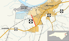
North Carolina Highway 149 (NC 149) is a primary state highway in the U.S. state of North Carolina. The highway provides direct access from US 64 to the Plymouth Pulp Mill.
| ||||
|---|---|---|---|---|
| Ken Trowbridge Road | ||||
 | ||||
| Route information | ||||
| Maintained by NCDOT | ||||
| Length | 1.2 mi[1] (1.9 km) | |||
| Existed | 1987–present | |||
| Major junctions | ||||
| South end | ||||
| North end | Plymouth Pulp Mill near Plymouth | |||
| Location | ||||
| Counties | Washington | |||
| Highway system | ||||
| ||||
Route description
NC 149 is a short 1.17-mile (1.88 km) two-lane highway, connecting US 64 with the Domtar's Plymouth Pulp Mill, where they make Cellulose fiber and Fluff pulp. A gate is located just past from where state maintenance ends.
History
NC 149 was established by 1987 as a new primary spur from US 64 to the Plymouth Pulp Mill, an upgrade of Ken Trowbridge Road (SR 1341).[2] It has remained unchanged since inception.
Junction list
The entire route is in Plymouth, Washington County.
| mi[1] | km | Destinations | Notes | ||
|---|---|---|---|---|---|
| 0.00 | 0.00 | ||||
| 1.17 | 1.88 | Plymouth Pulp Mill | Gate entrance, restricted access | ||
| 1.000 mi = 1.609 km; 1.000 km = 0.621 mi | |||||
gollark: Due to technical limitations it relies on a server, but you can host your own.
gollark: Over websockets.
gollark: Modemless networking.
gollark: emux.cc or whatever.
gollark: Use CCemux.
References
- Google (June 11, 2014). "North Carolina Highway 149" (Map). Google Maps. Google. Retrieved June 11, 2014.
- North Carolina Official Highway Map (PDF) (Map). Cartography by NCDOT. North Carolina Department of Transportation. 1990. Retrieved June 11, 2014.
External links

- NCRoads.com: N.C. 149
This article is issued from Wikipedia. The text is licensed under Creative Commons - Attribution - Sharealike. Additional terms may apply for the media files.
