North Carolina Highway 142
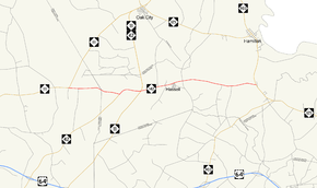
North Carolina Highway 142 (NC 142) is a primary state highway in the U.S. state of North Carolina that goes through the town of Hassell. The entire route is two lanes wide.
| ||||
|---|---|---|---|---|
 | ||||
| Route information | ||||
| Auxiliary route of NC 42 | ||||
| Maintained by NCDOT | ||||
| Length | 9.2 mi (14.8 km) | |||
| Existed | 1975[1]–present | |||
| Major junctions | ||||
| West end | ||||
| East end | ||||
| Location | ||||
| Counties | Edgecombe, Martin | |||
| Highway system | ||||
| ||||
Route description
The western terminus of the highway is NC 111. Traveling east 2.5-mile (4.0 km), the highway beings a brief 1.1-mile (1.8 km) concurrency with NC 42 and joins the Tar Heel Trace scenic byway.[2] NC 42 departs the route at the NC 11 intersection, NC 142 continues 1.4-mile (2.3 km) to the rural community of Hassell. Leaving Hassell to the east, NC 142 terminates after 3.7-mile (6.0 km) with the NC 125/NC 903 junction. The Tar Heel Trace continues southbound on NC 125.
History
The route was created in 1975 as part of a rerouting of NC 42, which formerly ran from the current NC 11/NC 42/NC 142 junction to the NC 125/NC 903 junction. In 1980 the route was expanded west to its current profile by promoting two secondary routes in Edgecombe and Martin County.[1]
Junction list
| County | Location | mi | km | Destinations | Notes |
|---|---|---|---|---|---|
| Edgecombe | Fountain Fork | 0.0 | 0.0 | Western terminus | |
| Martin | | 2.5 | 4.0 | West end of NC 42 concurrency | |
| | 3.6 | 5.8 | East end of NC 42 concurrency | ||
| | 9.2 | 14.8 | Eastern terminus | ||
1.000 mi = 1.609 km; 1.000 km = 0.621 mi
| |||||
References
- "NCRoads.com N.C. 142". Retrieved 2011-10-04.
- "North Carolina Scenic Byways Fourth Edition" (PDF). Archived from the original (PDF) on 2011-10-10. Retrieved 2011-10-04.
