Norra Storfjället
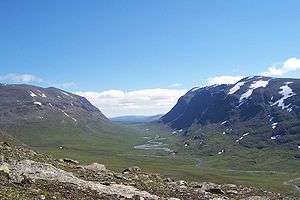
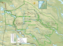
Norra Storfjället is a mountain range located in the county of Västerbotten, in Laponie Sweden. The mountain range is, for the most part, located within Vindelfjällens Nature Reserve. It reaches a maximum height of 1,768 m (5,801 ft) at the peak known as Norra Sytertoppen.[1] Other peaks include Måskostjakke (1,690 m (5,540 ft)) and Södra Sytertoppen (1,685 m (5,528 ft)).[1] It is divided approximately in half by a deep valley, the valley of Syterskalet/Viterskalet. This U-shaped valley is one of the renowned natural icons of the reserve and is remarkably similar to the Lapporten located 700 km (430 mi) to the north. A ski area lies on the southeast side of the massif, near Hemavan.
| Norra Storfjället | |
|---|---|
 U-shaped valley of Syterskalet, dividing the Norra Storfjället mountain range | |
| Highest point | |
| Elevation | 1,768 m (5,801 ft) |
| Coordinates | 65°52′59″N 15°14′00″E |
| Geography | |
| Location | Laponie, Sweden |
| Parent range | Scandavian Mountains |

Map of Vindelfjällens Nature Reserve with Norra Storfjället along the western border.
Gallery
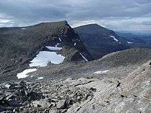
 Södra Sytertoppen in the foreground and Norra Sytertoppen in the background.
 Norra Sytertoppen, the highest point of the Norra Storfjället mountain range.
 View of Norra Storfjället from a distance
gollark: Update: it is degree n - 1 you need, as I just determined via methods.
gollark: No, it's probably not a mere Lagrange interpolation limitation, that would make no sense.
gollark: I forgot how any of this works, and it may just have been entirely based on wikipedia.
gollark: ↓ HIGHLY optimized code
gollark: Unless two points have the same x, although that might just be Lagrange interpolation.
References
- data collected from this map
This article is issued from Wikipedia. The text is licensed under Creative Commons - Attribution - Sharealike. Additional terms may apply for the media files.