Nong Saeng District, Udon Thani
Nong Saeng (Thai: หนองแสง, pronounced [nɔ̌ːŋ sɛ̌ːŋ]) is a district (amphoe) of Udon Thani Province, northeastern Thailand.
Nong Saeng หนองแสง | |
|---|---|
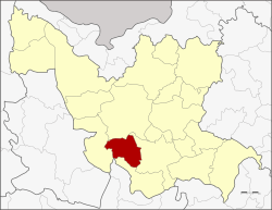 District location in Udon Thani Province | |
| Coordinates: 17°10′3″N 102°46′50″E | |
| Country | Thailand |
| Province | Udon Thani |
| Seat | Thap Kung |
| Area | |
| • Total | 659.4 km2 (254.6 sq mi) |
| Population (2005) | |
| • Total | 25,802 |
| • Density | 39.1/km2 (101/sq mi) |
| Time zone | UTC+7 (ICT) |
| Postal code | 41340 |
| Geocode | 4121 |
Geography
Neighboring districts are (from the west clockwise) Nong Wua So, Mueang Udon Thani, Kumphawapi, and Non Sa-at of Udon Thani Province, and Khao Suan Kwang of Khon Kaen Province.
History
The area of the district was originally part of Kumphawapi District. It was made a minor district (king amphoe) on 1 January 1981,[1] then consisting of two tambons and 27 villages. The district office was opened in village three of tambon Nong Saeng on 1 January 1983.[2]
Administration
The district is divided into four sub-districts (tambons), which are further subdivided into 38 villages (mubans). Saeng Sawang is a township (thesaban tambon) which covers parts of tambon Saeng Sawang. There are a further four tambon administrative organizations (TAO).
| No. | Name | Thai name | Villages | Pop. | |
|---|---|---|---|---|---|
| 1. | Nong Saeng | หนองแสง | 8 | 4,461 | |
| 2. | Saeng Sawang | แสงสว่าง | 8 | 7,157 | |
| 3. | Na Di | นาดี | 11 | 6,305 | |
| 4. | Thap Kung | ทับกุง | 11 | 7,879 |
References
- ประกาศกระทรวงมหาดไทย เรื่อง แบ่งท้องที่อำเภอกุมภวาปี จังหวัดอุดรธานี ตั้งเป็นกิ่งอำเภอหนองแสง (PDF). Royal Gazette (in Thai). 104 (1 ง special): 5. January 1, 1981.
- พระราชกฤษฎีกาตั้งอำเภอนามน อำเภอพระยืน อำเภอหนองบัวระเหว อำเภอบ้านเหลื่อม อำเภอจะแนะ อำเภอหนองหงส์ อำเภอนาโพธิ์ อำเภอเกาะยาว อำเภอแกดำ อำเภอสระโบสถ์ อำเภอโนนคูณ อำเภอควนโดน อำเภอไชยวาน อำเภอหนองแสง และอำเภอตาลสุม พ.ศ. ๒๕๓๐ (PDF). Royal Gazette (in Thai). 104 (278 ก special): 33–37. December 31, 1987.