Nimpkish River
The Nimpkish River is a river in northern Vancouver Island in British Columbia, Canada. It is the longest river on the Island, rising on the west slope of Mount Alston, flowing northwest into Nimpkish Lake and then north into the Broughton Strait[1] at a point 8 km east of Port McNeill, just southwest of the town of Alert Bay on Cormorant Island.
| Nimpkish River | |
|---|---|
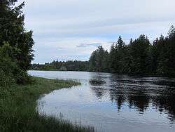 The Nimpkish River below Nimpkish Lake | |
| Location | |
| Country | Canada |
| Province | British Columbia |
| Region | Northern Vancouver Island |
| Physical characteristics | |
| Source | |
| • location | Mount Alston |
| • coordinates | 50.0177°N 126.2352°W |
| • elevation | 1,415 m (4,642 ft) |
| Mouth | |
• location | Broughton Strait |
• coordinates | 50°33′59″N 126°58′55″W |
• elevation | 0 m (0 ft) |
| Length | 118.1 km (73.4 mi) |
Name origin
"Nimpkish" is an anglicization of the Kwak'wala name for the people of this area, the 'Namgis.
gollark: ah yesrandom hexadecimal
gollark: ...
gollark: An index of all the games and s tuff.
gollark: ?
gollark: ++delete long polling
References
This article is issued from Wikipedia. The text is licensed under Creative Commons - Attribution - Sharealike. Additional terms may apply for the media files.