New York State Route 355
New York State Route 355 (NY 355) is an east–west state highway in Rensselaer County, New York, in the United States. The western terminus of the route is at an intersection with NY 66 in the town of North Greenbush. Its eastern terminus is at a junction with NY 351 in the hamlet of Poestenkill within the town of the same name. NY 355 originally consisted only of the section of the route between NY 66 and Spring Avenue; however, it was extended east to Postenkill hamlet in 1980, partially replacing NY 154.
| ||||
|---|---|---|---|---|
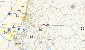
 Map of Rensselaer County in eastern New York with NY 355 highlighted in red | ||||
| Route information | ||||
| Maintained by NYSDOT | ||||
| Length | 2.94 mi[1] (4.73 km) | |||
| Existed | by 1946[2]–present | |||
| Major junctions | ||||
| West end | ||||
| East end | ||||
| Location | ||||
| Counties | Rensselaer | |||
| Highway system | ||||
| ||||
Route description
NY 355 begins at an intersection with NY 66 in the town of North Greenbush. The highway proceeds eastward into the town of Poestenkill, passing to the south of residential homes and Moules Pond. Route 355 is known for most of its length as Cooper Hill Road as it heads eastward towards downtown Poestenkill. County Route 130 (CR 130, formerly NY 154) merges in from the northeast and the route changes names to Spring Avenue. NY 355 continues, passing to the north of Rensselaer County Airpark. NY 355 terminates at an intersection with NY 351 and CR 40 in the hamlet of Poestenkill.[3]
History
NY 355 was assigned by 1946 to a short connector highway between NY 66 in North Greenbush and NY 154 (Spring Avenue) in the town of Poestenkill. From there, NY 154 continued east to the hamlet of Poestenkill, where it ended at a junction with Round Top and White Church Roads.[2] On April 1, 1980, ownership and maintenance of NY 154 from the Troy city line to NY 355 was transferred from the state of New York to Rensselaer County as part of a highway maintenance swap.[4] The NY 154 designation was completely removed on May 14, 1980, and the portion of NY 154's routing that was not given to Rensselaer County became an eastward extension of NY 355.[5]
Major intersections
The entire route is in Rensselaer County.
| Location | mi[1] | km | Destinations | Notes | |
|---|---|---|---|---|---|
| North Greenbush | 0.00 | 0.00 | Western terminus | ||
| Town of Poestenkill | 1.14 | 1.83 | Eastern terminus of CR 130 (formerly part of NY 154) | ||
| Community of Poestenkill | 2.94 | 4.73 | Eastern terminus, western terminus of CR 40 | ||
| 1.000 mi = 1.609 km; 1.000 km = 0.621 mi | |||||
See also

References
- "2008 Traffic Volume Report for New York State" (PDF). New York State Department of Transportation. June 16, 2009. p. 218. Retrieved January 31, 2010.
- New York with Pennsylvania (Map). Cartography by Rand McNally and Company. Texaco. 1946.
- Google (March 24, 2008). "overview map of NY 355" (Map). Google Maps. Google. Retrieved March 24, 2008.
- New York State Legislature. "New York State Highway Law § 341". Retrieved July 7, 2009.
- New York State Department of Transportation (January 2017). Official Description of Highway Touring Routes, Bicycling Touring Routes, Scenic Byways, & Commemorative/Memorial Designations in New York State (PDF). Retrieved January 9, 2017.
