New Mexico State Road 573
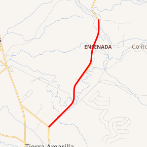
State Road 573 (NM 573) is a 2.22-mile-long (3.57 km) state highway in the US state of New Mexico. NM 573's southern terminus is at NM 162 in Tierra Amarilla, and the northern terminus is a continuation as County Route 331 (CR 331) at the intersection of CR 327 north of Tierra Amarilla. CR 331 continues north to NM 512.
| ||||
|---|---|---|---|---|

NM 573 highlighted in red | ||||
| Route information | ||||
| Maintained by NMDOT | ||||
| Length | 2.220 mi[1] (3.573 km) | |||
| Existed | 1988–present | |||
| Major junctions | ||||
| South end | ||||
| North end | ||||
| Location | ||||
| Counties | Rio Arriba | |||
| Highway system | ||||
| ||||
History
From the 1950s until 1988 NM 573 was originally NM 162. NM 573 was created in 1988 after NM 162's northern terminus was changed to its current location.[2][3]
Major intersections
The entire route is in Rio Arriba County.
| Location | mi[4] | km | Destinations | Notes | |
|---|---|---|---|---|---|
| Tierra Amarilla | 0.000 | 0.000 | Southern terminus | ||
| | 2.220 | 3.573 | Northern terminus, continues north to NM 512 as CR 331, western terminus of CR 327 | ||
| 1.000 mi = 1.609 km; 1.000 km = 0.621 mi | |||||
gollark: What do you think of RISC-V then?
gollark: yes.
gollark: "arm bad because arm not x86"
gollark: *cue anti-ARM rant*
gollark: I mean, quite a few of those apply to ARM too.
See also

References
- "Posted Route: Legal Description" (PDF). New Mexico Department of Transportation. March 16, 2010. p. 91. Retrieved October 10, 2018.
- Riner, Steve (January 19, 2008). "New Mexico Highways". State Routes 1–25, State Routes 26–50, State Routes 51–75, State Routes 76–100, State Routes 101–125, State Routes 126–150, State Routes 151–175, State Routes 176–200, State Routes 201–250, State Routes 251–300, State Routes 301–350, State Routes 351–400, State Routes 401–450, State Routes 451–500, State Routes 501–550, State Routes 551–600, State Routes 601–6563, U.S. and Interstate Highways. Retrieved April 13, 2015.
- 1964 USGS Topo Map
- "TIMS Road Segments by Posted Route/Point with AADT Info; NM, X-Routes" (PDF). New Mexico Department of Transportation. April 3, 2013. pp. 5–7. Retrieved December 20, 2013.
External links
This article is issued from Wikipedia. The text is licensed under Creative Commons - Attribution - Sharealike. Additional terms may apply for the media files.
