New Mexico State Road 333
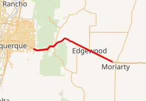
State Road 333 (NM 333) is a 27.715-mile-long (44.603 km) state highway in the US state of New Mexico. NM 333's western terminus is at Interstate 40 (I-40) and NM 556 in Albuquerque, and the eastern terminus is at Interstate 40 Business (I-40 Bus.) in Moriarty. The entire route serves as a frontage road to Interstate 40.
| ||||
|---|---|---|---|---|
NM 333 highlighted in red | ||||
| Route information | ||||
| Maintained by NMDOT | ||||
| Length | 27.715 mi[1] (44.603 km) | |||
| Major junctions | ||||
| West end | ||||
| East end | ||||
| Location | ||||
| Counties | Bernalillo, Santa Fe, Torrance | |||
| Highway system | ||||
| ||||

Route description
NM 333 begins in eastern Albuquerque at an intersection of Tramway Boulevard (NM 556) and Central Avenue, proceeding east on Central, the route of the former U.S. Route 66 (US 66). After a partial interchange with Interstate 40 (I-40), the highway enters the Sandia Mountains through Tijeras Canyon, where it crosses to the north side of I-40 in a diamond interchange. After traveling through Carnuel, it crosses back to the south side of I-40, though this crossing has no interchange.
Before entering the town of Tijeras, there is a "musical road" feature where rumble strips are arranged to play America the Beautiful for eastbound travelers.[2] Once in Tijeras itself, the highway intersects NM 337, which travels to the southeast, and NM 14, which heads northeast to Santa Fe. Continuing east, NM 333 travels through Sedillo, where it intersects the former NM 306 and NM 217. The highway then leaves Bernalillo County, and enters Santa Fe County and the town of Edgewood, where it intersects NM 344. Shortly thereafter, the highway enters Torrance County and the city of Moriarty, where it ends at an intersection with I-40 Business (I-40 Bus.).[3]
History
NM 333 follows the routing of the former Historic U.S. Route 66.
Major intersections
| County | Location | mi[4] | km | Destinations | Notes |
|---|---|---|---|---|---|
| Bernalillo | Albuquerque | 0.000 | 0.000 | Western terminus; I-40 exit 167 | |
| Carnuel | 2.060 | 3.315 | I-40 exit 170 | ||
| Tijeras | 6.810 | 10.960 | To I-40 exit 175 westbound on/ off ramps via NM 337 north | ||
| | 7.404 | 11.916 | Southern terminus of NM 14; to I-40 exit 175 westbound on/ off ramps only | ||
| | 7.564 | 12.173 | I-40 exit 175 eastbound on ramp only | ||
| | 10.164 | 16.357 | Access Road (FR 4058) | To I-40 exit 178 | |
| | 13.764 | 22.151 | I-40 exit 181 eastbound on/ off ramps only | ||
| | 13.950 | 22.450 | Sedillo Road | Southern terminus of former NM 306; to I-40 exit 181 westbound on/ off ramps only | |
| | 15.342 | 24.691 | Northern terminus of NM 217 | ||
| Santa Fe | Edgewood | 19.737 | 31.764 | Southern terminus of NM 344; to I-40 exit 187 | |
| Torrance | Moriarty | 27.715 | 44.603 | Eastern terminus | |
| 1.000 mi = 1.609 km; 1.000 km = 0.621 mi | |||||
See also

References
- "Posted Route: Legal Description" (PDF). New Mexico Department of Transportation. March 16, 2010. p. 91. Retrieved October 25, 2018.
- "Route 66 ‘singing road’ debuts in New Mexico", KRQE News 13 (TV), October 1, 2014.
- Google (January 27, 2019). "Overview map of NM 333" (Map). Google Maps. Google. Retrieved January 27, 2019.
- "TIMS Road Segments by Posted Route/Point with AADT Info; NM, NMX-Routes" (PDF). New Mexico Department of Transportation. April 3, 2013. pp. 5–7. Retrieved October 20, 2018.