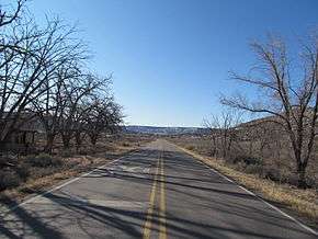
New Mexico State Road 24
State Road 24 (NM 24) is a state highway in the US state of New Mexico. Its total length is approximately 52 miles (84 km). NM 24's western terminus is at NM 130 southwest of Mayhill, and the eastern terminus is at U.S. Route 82 (US 82) north-northeast of Dunken.
| ||||
|---|---|---|---|---|
| Route information | ||||
| Maintained by NMDOT | ||||
| Length | 52.023 mi[1] (83.723 km) | |||
| Major junctions | ||||
| West end | ||||
| East end | ||||
| Location | ||||
| Counties | Otero, Chaves | |||
| Highway system | ||||
| ||||

NM 24 near Seama.
Major intersections
| County | Location | mi[2] | km | Destinations | Notes |
|---|---|---|---|---|---|
| Otero | | 0.000 | 0.000 | Western terminus | |
| Weed | 4.975 | 8.006 | Agua Chiquita Road | Eastern terminus of former NM 521 | |
| Chaves | | 52.023 | 83.723 | Eastern terminus | |
| 1.000 mi = 1.609 km; 1.000 km = 0.621 mi | |||||
gollark: Please, even LyricTech™ can do that.
gollark: There is an ongoing operation to construct a partial Dyson swarm from Mercury, which will contain high-performance computing clusters as well as energy production for transmission back to other Santa facilities.
gollark: Santa's computational capacity is not sufficient to break post-quantum cryptosystems.
gollark: He receives inbound materials from various lunar/asteroid-belt mining operations and delivers finalized products to the low-orbital disbursement satellites.
gollark: Santa's main production base is situated at the Earth-Moon L5 point.
See also

References
- "Posted Route: Legal Description" (PDF). New Mexico Department of Transportation. March 16, 2010. p. 91. Retrieved October 10, 2018.
- "TIMS Road Segments by Posted Route/Point with AADT Info; NM, NMX-Routes" (PDF). New Mexico Department of Transportation. April 3, 2013. pp. 5–7. Retrieved October 10, 2018.
This article is issued from Wikipedia. The text is licensed under Creative Commons - Attribution - Sharealike. Additional terms may apply for the media files.
