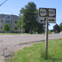
New Brunswick Route 850
Route 850 is a Canadian highway in Kings County, New Brunswick.

Route sign in Kingston, New Brunswick.
| ||||
|---|---|---|---|---|
| Route information | ||||
| Maintained by New Brunswick Department of Transportation | ||||
| Length | 27.0 km[1] (16.8 mi) | |||
| Major junctions | ||||
| West end | ||||
| East end | ||||
| Location | ||||
| Counties | Kings | |||
| Highway system | ||||
| Provincial highways in New Brunswick Former routes
| ||||
The 27 kilometre road passes along the northern side of the Kingston Peninsula.
Route 850 begins near Springfield at an intersection with Route 124. Skirting the southern shore of Belleisle Bay, the route passes through Keirsteadville, Long Point and Erbs Cove, before terminating at Kingston at an intersection with Route 845. Just north of Erbs Cove, there is a cable ferry across Bellisle Bay. The ferry operates year-round. Much of the route passes through a narrow band of low lying agricultural land with forested hills rising in the background. This is a popular summer residential area and there is a small marina on the bay.
Communities along Route 850
- Kingston
- Urquhart
- Erbs Cove
- Long Point
- Keirsteadville
- Springfield
gollark: I mean, that one *is*.
gollark: You can probably trade purples for blues at least 2:3.
gollark: Their colours and magic changed; not that significant.
gollark: Wyrms, based on extrapolation from the lore thread, only got mana-transformed a bit.
gollark: Zyus actually have completely different colour-dependent body types!
References
- New Brunswick Department of Transportation: Designated Provincial Highways, 2003
This article is issued from Wikipedia. The text is licensed under Creative Commons - Attribution - Sharealike. Additional terms may apply for the media files.
