Nevada State Route 668
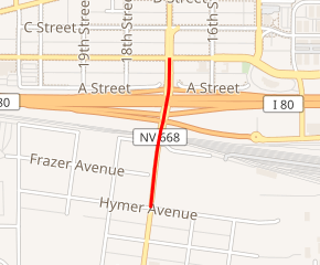
State Route 668 (SR 668) is a short state highway in Washoe County, Nevada. It runs along a small section of Rock Boulevard in Sparks.
| ||||
|---|---|---|---|---|
| Rock Boulevard | ||||

SR 668 highlighted in red | ||||
| Route information | ||||
| Maintained by NDOT | ||||
| Length | 0.314 mi[1] (0.505 km) | |||
| Existed | 1976–present | |||
| Major junctions | ||||
| South end | Hymer Avenue in Sparks | |||
| North end | ||||
| Highway system | ||||
| ||||
Route description
_near_Hymer_Avenue_in_Sparks%2C_Nevada.jpg)
View north along SR 668
State Route 668 begins at the intersection of South Rock Boulevard and Hymer Avenue in an industrial business section of Sparks. The route heads north from there along Rock Boulevard, passing underneath the Union Pacific railroad tracks and interchanging with Interstate 80 (I-80). SR 668 ends after 0.314 miles (0.505 km), at its intersection with Victorian Avenue (I-80 Business).[1][2]
History
The route was created on July 1, 1976, during the renumbering of Nevada's state highways.[3]
Major intersections
The entire route is in Sparks, Washoe County.
| mi | km | Destinations | Notes | ||
|---|---|---|---|---|---|
| 0.000 | 0.000 | Hymer Avenue | Southern terminus | ||
| 0.314 | 0.505 | Northern terminus | |||
| 1.000 mi = 1.609 km; 1.000 km = 0.621 mi | |||||
gollark: bcachefs will be neat if it is ever to occur.
gollark: The main issues seem to be with RAID so it's *probably* fine.
gollark: Also, yes, conservatism.
gollark: I *have* heard of stability issues.
gollark: Or AWS Glacier.
See also


References
- Nevada Department of Transportation (January 2017). "State Maintained Highways of Nevada: Descriptions and Maps". Retrieved 2017-01-19.
- Google (July 27, 2011). "Overview of SR 668" (Map). Google Maps. Google. Retrieved July 27, 2011.
- Nevada State Maintained Highways: Descriptions, Index and Maps. Nevada Department of Transportation. January 2001. p. 117.
| Wikimedia Commons has media related to Nevada State Route 668. |
This article is issued from Wikipedia. The text is licensed under Creative Commons - Attribution - Sharealike. Additional terms may apply for the media files.
