Nevada State Route 653
State Route 653 (SR 653) is an east–west state highway in Washoe County, Nevada, serving the city of Reno.
| ||||
|---|---|---|---|---|
| Plumb Lane | ||||
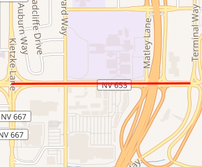
SR 653 highlighted in red | ||||
| Route information | ||||
| Maintained by NDOT | ||||
| Length | 0.589 mi[1] (0.948 km) | |||
| Existed | July 1, 1976–present | |||
| Major junctions | ||||
| West end | ||||
| East end | Terminal Way in Reno | |||
| Highway system | ||||
| ||||

Route description
_at_Kietzke_Lane_(Nevada_State_Route_667)_in_Reno%2C_Nevada.jpg)
The western end of SR 653
SR 653 begins at the intersection of Plumb Lane and Kietzke Lane (SR 667) in Reno, and proceeds east along Plumb Lane to end at the intersection with Terminal Way at the entrance to the Reno–Tahoe International Airport.
History
As late as 2006, the western terminus of SR 653 was at the intersection of Plumb Lane and S. Virginia Street (Business US 395; former SR 430). The route was truncated as of 2008.
Major intersections
The entire route is in Reno, Washoe County.
| mi | km | Destinations | Notes | ||
|---|---|---|---|---|---|
| Interchange; I-580 exit 33 | |||||
| Terminal Way | Reno–Tahoe International Airport entrance | ||||
| 1.000 mi = 1.609 km; 1.000 km = 0.621 mi | |||||
gollark: I can no longer hear you, do you exist?
gollark: https://osmarks.net/apioform/
gollark: https://mikipedia.fandom.com/wiki/Apioform_(compound)
gollark: https://www.youtube.com/watch?v=vdnyMRTiKo4
gollark: https://wiki.mondecitronne.com/wiki/Apioforms
See also


References
- Nevada Department of Transportation (January 2017). "State Maintained Highways of Nevada: Descriptions and Maps". Retrieved 2017-01-28.
| Wikimedia Commons has media related to Nevada State Route 653. |
This article is issued from Wikipedia. The text is licensed under Creative Commons - Attribution - Sharealike. Additional terms may apply for the media files.