Nebraska Highway 5
Nebraska Highway 5 is a highway in southern Nebraska. It has a southern terminus at an intersection with U.S. Highway 136 in Deshler and a northern terminus at an intersection with Nebraska Highway 4 between Davenport and Carleton. It is a north–south highway which lies entirely in Thayer County.
| ||||
|---|---|---|---|---|
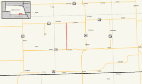 Nebraska Highway 5 highlighted in red | ||||
| Route information | ||||
| Maintained by NDOT | ||||
| Length | 11.04 mi[1] (17.77 km) | |||
| Existed | 1940[2]–present | |||
| Major junctions | ||||
| South end | ||||
| North end | ||||
| Location | ||||
| Counties | Thayer | |||
| Highway system | ||||
| ||||

Route description
Nebraska Highway 5 begins at an intersection with US 136 in Deshler. It heads directly to the north from Deshler, having no major intersections with other highways as it passes through farmland. It terminates at NE 4 east of Davenport.[1][3]
Major intersections
The entire route is in Thayer County.
| Location | mi[1] | km | Destinations | Notes | |
|---|---|---|---|---|---|
| Deshler | 0.00 | 0.00 | Southern terminus | ||
| Carleton | 11.04 | 17.77 | Northern terminus | ||
| 1.000 mi = 1.609 km; 1.000 km = 0.621 mi | |||||
gollark: It also instructs browsers to never use it over HTTP ever, via HSTS headers.
gollark: This is an important security feature.
gollark: osmarks.net will redirect you to HTTPS.
gollark: You can have an osmarksßsubdomain™.
gollark: https://media.discordapp.net/attachments/733347369847881838/923611039533248553/unknown.png
References
- "Nebraska Highway Reference Log Book" (PDF). Nebraska Department of Roads. 2015. p. 15. Retrieved January 6, 2017.
- The Nebraska Highways Page: Highways 1 to 30 Archived 2011-06-29 at the Wayback Machine
- Google (2010-11-01). "overview of Nebraska Highway 5" (Map). Google Maps. Google. Retrieved 2010-11-01.
External links
This article is issued from Wikipedia. The text is licensed under Creative Commons - Attribution - Sharealike. Additional terms may apply for the media files.