Nebraska Highway 128
Nebraska Highway 128 (N-128) is a highway in southeastern Nebraska. It has a western terminus at Nebraska Highway 50 south of Syracuse and an eastern terminus at U.S. Highway 75 south of Nebraska City.
| ||||
|---|---|---|---|---|
| N Road | ||||
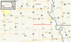 Nebraska Highway 128 highlighted in red | ||||
| Route information | ||||
| Maintained by NDOT | ||||
| Length | 16.84 mi[1] (27.10 km) | |||
| Major junctions | ||||
| West end | ||||
| East end | ||||
| Location | ||||
| Counties | Otoe | |||
| Highway system | ||||
| ||||

Route description
N-128 begins at an intersection with N-50 south of Syracuse and heads east through farmland. Just west of Lorton, it meets Nebraska Highway 67. They run concurrent through Lorton, and separate east of there. N-128 continues east through the unincorporated community of Paul and ends shortly afterward at US 75.[1][2]
Major intersections
The entire route is in Otoe County.
| Location | mi[1] | km | Destinations | Notes | |
|---|---|---|---|---|---|
| | 0.00 | 0.00 | Western terminus; road continues as N Road | ||
| Lorton | 7.90 | 12.71 | West end of NE 67 overlap | ||
| 8.89 | 14.31 | East end of NE 67 overlap | |||
| | 16.84 | 27.10 | Eastern terminus; road continues as N Road | ||
1.000 mi = 1.609 km; 1.000 km = 0.621 mi
| |||||
gollark: You can send it to the osmarks.tk™ open source spying™ API.
gollark: Why not send me a copy of your internet browser history?
gollark: ```pythonprint("." * 300)```
gollark: ........................................................................................................................
gollark: Be creative. There is a lot of data to be gathered™: your internet browsing history, probably other programs on your computer, sort of thing.
References
- "Nebraska Highway Reference Log Book" (PDF). Nebraska Department of Roads. 2015. p. 269. Retrieved January 7, 2017.
- Google (2010-11-08). "overview of Nebraska Highway 128" (Map). Google Maps. Google. Retrieved 2010-11-08.
This article is issued from Wikipedia. The text is licensed under Creative Commons - Attribution - Sharealike. Additional terms may apply for the media files.